|
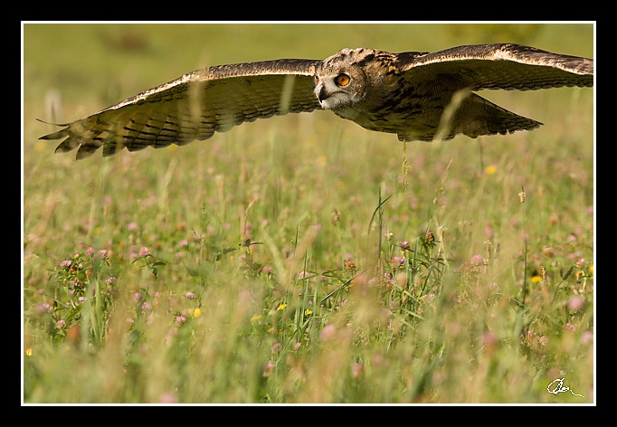
| 2 GPS 22. 08. 2010 09:45:51, Luka nad Jihlavou, 1/2500 sec, f 5.6, ISO 800 , 200 mm, Blesk No Flash |
Cesta
2010/08 srpen/22 Fotokurz dravci II/20100822-018.jpgContains Exchangeable Image File Format (EXIF) Information
Main Image Information
| Image Width | 682 pixels |
| Image Length | 472 pixels |
| Compression | Uncompressed |
| Photometric Interpretation | RGB (Red Green Blue) |
| Make (Manufacturer) | Canon |
| Model | Canon EOS 40D |
| X Resolution | 1207959552/16777216 (72) pixels per 'Resolution Unit' |
| Y Resolution | 1207959552/16777216 (72) pixels per 'Resolution Unit' |
| Planar Configuration | Chunky Format |
| Resolution Unit | Inches |
| Date and Time | 2010:08:27 08:22:38 (Format: YYYY:MM:DD HH:mm:SS) |
| YCbCr Positioning | Chrominance components Centred in relation to luminance components |
EXIF Image File Directory (IFD) contents
| Exposure Time | 1/2500 (0.0004) seconds |
| Aperture F Number | 56/10 (5.6) |
| Exposure Program | Manual |
| ISO Speed Ratings | 800 |
| Exif Version | 0221 |
| Date and Time of Original | 2010:08:22 09:45:51 |
| Date and Time when Digitized | 2010:08:22 09:45:51 |
| APEX Shutter Speed Value (Tv) | 11287712/1000000 (11.287712) |
| APEX Aperture Value (Av) | 4970854/1000000 (4.970854) |
| APEX Exposure Bias Value (Exposure Compensation) | 0/1 (0) EV |
| Metering Mode | Pattern |
| Flash | Flash did not fire, compulsory flash suppression mode |
| FocalLength | 200/1 (200) mm |
| Sub Second Time of Original | 09 |
| Sub Second Time when Digitized | 09 |
| Focal Plane X Resolution | 3888000/876 (4438.3561643836) pixels per 'Focal Plane Resolution Unit' |
| Focal Plane Y Resolution | 2592000/583 (4445.9691252144) pixels per 'Focal Plane Resolution Unit' |
| Focal Plane Resolution Unit | Inches |
| Special Processing (Custom Rendered) | Normal process |
| Exposure Mode | Manual exposure |
| White Balance | Manual white balance |
| Scene Capture Type | Standard |
| Pixel X Dimension | 682 pixels |
| Pixel Y Dimension | 472 pixels |
| Colour Space | Uncalibrated |
| Components Configuration | Component 1: Y (Luminance) Component 2: Cb (Chroma minus Blue) Component 3: Cr (Chroma minus Red) Component 4: Does not exist |
| User Comment |
GPS Info Image File Directory (IFD) contents
| Longitude | 15/1 (15), 4226550/100000 (42.2655), 0/0 (Degrees Minutes Seconds East or West) |
| East or West Longitude | E |
| Latitude | 49/1 (49), 2209272/100000 (22.09272), 0/0 (Degrees Minutes Seconds North or South) |
| North or South Latitude | N |
| Altitude | 490890/1000 (490.89) Metres with respect to Altitude Reference |
| Altitude Reference | Sea Level |
Contains Extensible Metadata Platform (XMP) / Resource Description Framework (RDF) Information
Dublin Core Metadata Initiative RDF Segment
| Creator(s) (Authors): | Ordered List: Ing. Daniel Žingor |
| Rights Statement: | List of Alternates: © Daniel Žingor |
| Subject and Keywords: | Unordered List: Příroda Zvířata Web |
XMP Basic Segment
| Resource Last Modify Date: | 2010-08-22T13:45:59+02:00 |
| Original Creation Date: | 2010-08-22T09:45:51.09+02:00 |
| Unknown field xap:Rating: | 2 |
| Unknown field xap:Label: | Green |
XMP - embedded TIFF Segment
| Make: | Canon |
| Model: | Canon EOS 40D |
| Image Width: | 3888 |
| Image Length: | 2592 |
| Samples Per Pixel: | 3 |
| Bits Per Sample: | Ordered List: 16 16 16 |
| Photometric Interpretation: | 2 |
XMP - embedded EXIF Segment
| Exif Version: | 0221 |
| Exposure Time: | 1/2500 |
| Shutter Speed Value: | 11287712/1000000 |
| F Number: | 56/10 |
| Aperture Value: | 4970854/1000000 |
| Exposure Program: | 1 |
| Date & Time of Original: | 2010-08-22T09:45:51.09+02:00 |
| Date & Time Digitized: | 2010-08-22T09:45:51.09+02:00 |
| Exposure Bias Value: | 0/1 |
| Metering Mode: | 5 |
| Focal Length: | 200/1 |
| Custom Rendered: | 0 |
| Exposure Mode: | 1 |
| White Balance: | 1 |
| Scene Capture Type: | 0 |
| Focal Plane X Resolution: | 3888000/876 |
| Focal Plane Y Resolution: | 2592000/583 |
| Focal Plane Resolution Unit: | 2 |
| ISO Speed Ratings: | Ordered List: 800 |
| Flash: | Fired = False Return = 0 Mode = 2 Function = False Red Eye Mode = False |
| Pixel X Dimension: | 3888 |
| Pixel Y Dimension: | 2592 |
| GPS Longitude: | 15,42.265499E |
| GPS Latitude: | 49,22.092720N |
| GPS Altitude: | 490890/1000 |
| GPS Altitude Reference: | 0 |
Unknown RDF Segment 'aux'
| Unknown field aux:Lens: | 70.00 - 200.00 mm |
| Unknown field aux:Firmware: | Firmware Version 1.0.3 |
Photoshop RDF Segment
| Unknown field photoshop:LegacyIPTCDigest: | EA20940AFBF52D322CB867DF2CB70E1C |
Unknown RDF Segment 'znr'
| Unknown field znr:RawDevelopSettings: | UEsDBBQAAAAIALxtFj3KhDVVvAIAAF4JAAAMAAAAc2V0dGluZ3MueG1sbZZLbtwwDIb3BXqTTuJx 3kEgIGj3BbrORpE5YyGyZFDypJOrddEj9QqVberpzEr8+JOyKJqef3/+Pn3g+2MHJ1BmZF+/LOaz QuDd+XkclYSO7Z8uP6GktShG7nr24/GlM2/TANqdX36+Iv94O7+0zb7ZNfe7tl2WzX3b7pr9/cX3 X+2aM0RTMo5OHrhwB6kcICNRRUmr5LF3ljWrhqzwUD3vzHt0BpO8wmiH3LrgjnbwK47SnaObTPI6 GEZA7iYEdnt3dbOKchrS8CGnIVtJQ1KpHdvdUa7ZyJLMZhadee2chDtpNPPVpcMmRqqT9NehBSRN JKTop/h885Lo+2uAfkXsYHDgjl2tnCzydTAYy6UIUdGOdVcG7chFKkYiIb9U4BuRWo4s8k12sA5B H33D3FKGnCUZ8k5Olu0v2iQjlkSuR7C9UV3os4IlnZoGo9U5PFNGSAO/R2GGkTUXob6BkECjjwhn Xo3o8SVIntlILYyjBps3MYFQbjEyKrSIW/lG1na+lhCWACnQOO5geViSEAm3hGZEEG5V+N+3uNjX C7rFEBH7wLrlrQ5tQGZqIQGd5gOw2EUBFO+2C3dxXbzkrroiers36poXuV8V6M7KD2B3RfLEy+xb /cZR5Z+wk/5I88S6qrbIXPUun0R95iv28gMBtJ1H1PVNvlHi5S5b/cZR5IcTa4sLj7jMu9ElHrrT aBATnsLNJ7sYEb08OJZPiAWQ5Ij8jP77E8oT7Mx9RADNbh6SYCWZxFfTz8N9UiwgCsw0+nfY2HlE R1EOc6WfjrkmDcvFXE5QCFay0aynbGphdXiP0yTIs27mw0JThXPtpu4L1UZa8KWcxPpFyQIqV7FD HDDFDvXYoQPpE6Cts2e4UPtmRz6imT8DZUDhyWP6Dss/BhWttNUfhRrn6rlJrOAKCnGiXntZ/pf6 D1BLAQIAABQAAAAIALxtFj3KhDVVvAIAAF4JAAAMAAAAAAAAAAEAIAAAAAAAAABzZXR0aW5ncy54 bWxQSwUGAAAAAAEAAQA6AAAA5gIAAAAA |
Unknown RDF Segment 'Iptc4xmpCore'
| Unknown field Iptc4xmpCore:Location: | Luka nad Jihlavou |
