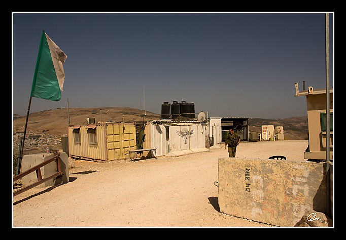
| ... dojíždíme k vojenskému stanovišti (jako před pěti lety) :) ... |
| 2 GPS 29. 06. 2010 09:30:10, Izrael - Elon More, 1/3200 sec, f 5.6, ISO 200 , 17 mm, Blesk No Flash |
Cesta
2010/06 cerven/29 Samari a Shekem-Nablus/20100629-013.jpgContains Exchangeable Image File Format (EXIF) Information
Main Image Information
| Image Width | 682 pixels |
| Image Length | 472 pixels |
| Compression | Uncompressed |
| Photometric Interpretation | RGB (Red Green Blue) |
| Make (Manufacturer) | Canon |
| Model | Canon EOS 40D |
| X Resolution | 1207959552/16777216 (72) pixels per 'Resolution Unit' |
| Y Resolution | 1207959552/16777216 (72) pixels per 'Resolution Unit' |
| Planar Configuration | Chunky Format |
| Resolution Unit | Inches |
| Date and Time | 2010:07:09 12:07:50 (Format: YYYY:MM:DD HH:mm:SS) |
| YCbCr Positioning | Chrominance components Centred in relation to luminance components |
EXIF Image File Directory (IFD) contents
| Exposure Time | 1/3200 (0.0003125) seconds |
| Aperture F Number | 56/10 (5.6) |
| Exposure Program | Aperture priority |
| ISO Speed Ratings | 200 |
| Exif Version | 0221 |
| Date and Time of Original | 2010:06:29 09:30:10 |
| Date and Time when Digitized | 2010:06:29 09:30:10 |
| APEX Shutter Speed Value (Tv) | 11643856/1000000 (11.643856) |
| APEX Aperture Value (Av) | 4970854/1000000 (4.970854) |
| APEX Exposure Bias Value (Exposure Compensation) | 0/1 (0) EV |
| Metering Mode | Pattern |
| Flash | Flash did not fire, compulsory flash suppression mode |
| FocalLength | 17/1 (17) mm |
| Sub Second Time of Original | 00 |
| Sub Second Time when Digitized | 00 |
| Focal Plane X Resolution | 3888000/876 (4438.3561643836) pixels per 'Focal Plane Resolution Unit' |
| Focal Plane Y Resolution | 2592000/583 (4445.9691252144) pixels per 'Focal Plane Resolution Unit' |
| Focal Plane Resolution Unit | Inches |
| Special Processing (Custom Rendered) | Normal process |
| Exposure Mode | Auto exposure |
| White Balance | Manual white balance |
| Scene Capture Type | Standard |
| Pixel X Dimension | 682 pixels |
| Pixel Y Dimension | 472 pixels |
| Colour Space | Uncalibrated |
| Components Configuration | Component 1: Y (Luminance) Component 2: Cb (Chroma minus Blue) Component 3: Cr (Chroma minus Red) Component 4: Does not exist |
| User Comment |
GPS Info Image File Directory (IFD) contents
| Longitude | 35/1 (35), 1964040/100000 (19.6404), 0/0 (Degrees Minutes Seconds East or West) |
| East or West Longitude | E |
| Latitude | 32/1 (32), 1448022/100000 (14.48022), 0/0 (Degrees Minutes Seconds North or South) |
| North or South Latitude | N |
| Altitude | 733140/1000 (733.14) Metres with respect to Altitude Reference |
| Altitude Reference | Sea Level |
Contains Extensible Metadata Platform (XMP) / Resource Description Framework (RDF) Information
Dublin Core Metadata Initiative RDF Segment
| Creator(s) (Authors): | Ordered List: Ing. Daniel Žingor |
| Rights Statement: | List of Alternates: © Daniel Žingor |
| Subject and Keywords: | Unordered List: Reportáž The Best Of Web |
| Description (Caption): | List of Alternates: ... dojíždíme k vojenskému stanovišti (jako před pěti lety) :) ... |
XMP - embedded TIFF Segment
| Make: | Canon |
| Model: | Canon EOS 40D |
| Image Width: | 3888 |
| Image Length: | 2592 |
| Samples Per Pixel: | 3 |
| Bits Per Sample: | Ordered List: 16 16 16 |
| Photometric Interpretation: | 2 |
XMP - embedded EXIF Segment
| Exif Version: | 0221 |
| Exposure Time: | 1/3200 |
| Shutter Speed Value: | 11643856/1000000 |
| F Number: | 56/10 |
| Aperture Value: | 4970854/1000000 |
| Exposure Program: | 3 |
| Date & Time of Original: | 2010-06-29T09:30:10.00+02:00 |
| Date & Time Digitized: | 2010-06-29T09:30:10.00+02:00 |
| Exposure Bias Value: | 0/1 |
| Metering Mode: | 5 |
| Focal Length: | 17/1 |
| Custom Rendered: | 0 |
| Exposure Mode: | 0 |
| White Balance: | 1 |
| Scene Capture Type: | 0 |
| Focal Plane X Resolution: | 3888000/876 |
| Focal Plane Y Resolution: | 2592000/583 |
| Focal Plane Resolution Unit: | 2 |
| ISO Speed Ratings: | Ordered List: 200 |
| Flash: | Fired = False Return = 0 Mode = 2 Function = False Red Eye Mode = False |
| Pixel X Dimension: | 3888 |
| Pixel Y Dimension: | 2592 |
| GPS Longitude: | 35,19.640400E |
| GPS Latitude: | 32,14.480220N |
| GPS Altitude: | 733140/1000 |
| GPS Altitude Reference: | 0 |
XMP Basic Segment
| Resource Last Modify Date: | 2010-06-29T18:19:17+02:00 |
| Original Creation Date: | 2010-06-29T09:30:10.00+02:00 |
| Unknown field xap:Rating: | 2 |
| Unknown field xap:Label: | Green |
Unknown RDF Segment 'aux'
| Unknown field aux:Lens: | 17.00 - 50.00 mm |
| Unknown field aux:Firmware: | Firmware Version 1.0.3 |
Photoshop RDF Segment
| Unknown field photoshop:LegacyIPTCDigest: | EA20940AFBF52D322CB867DF2CB70E1C |
Unknown RDF Segment 'znr'
| Unknown field znr:RawDevelopSettings: | UEsDBBQAAAAIAGWS3TzfdgSj5QIAAKsJAAAMAAAAc2V0dGluZ3MueG1sbZZLbtswEIb3BXqHHiBO JDl2kCAgEKT7Au02G4YaW0QkkiApp85NeoieoIsuip6nVyglDZ+KV5pvfg7FmeHI/379vn/Tr3ct nKCXinz8MJsPvQbanh+U6jm0pL6/eoei1mimqO3I57unVr6MAwh7fvryrOnby/mpqepqU+03ze2n b3Sgf3/8+Tmzat/cbqp6e/n4tVmC+zAYlWrLD5TZA+8taIKigqK258fOGlItGrT823W0la/B6U30 MimspsZ6d7C9v6ea23Nwo4leC4MCTe2ogexvtrtFlFIfhg4p9dFy6oNyYcnmBmNNRhJkMpPViddM QajlUhCXXTxsZKg6cVcXwSBqAkFFN4b3mx6Rvj576J6QHaQeqCXbhaOFvhYGaShnflWwQ957qY2i LCYjEh+f9+A6EnsPLfSNZjBWgzi6htljhJRFmaYtHw2pL5soQxZFttNgOtm3vs8yFnX9OEjRn/07 JQQ18F0xOShSXfr8eoICod0Kf+bFCB6XguiZjNjCWgkwaRMj8OlmimCiWdjKNbIwU1n8sghQoaWl FuaXRQkSXyUtlQZmF4X7XYSHunzAKvoVoQ+MnW+1bwM0YwsxaAUdgIQu8iC729bX4jq75LYoEd7u lbrkWeznHkRr+BuQmyx45Hn0tX7lKOKPuuXuSNPE2hZbJK5yl3dWvefL9nIDAYSZRtT1Lt0o8nyX tX7lyOLDiTRZwQPO4650kfvulALYqE+u8rPJlJyH24VvVgRejmZT1xfNbrfSXOUxszHT8YMl6ZSZ AUqOmp61+5j5FHs7cR81gCC72yhYSCJxFXEztY6KGQSBHJWbA9JMYz6IUpgq3YRNNXHgzuZ8gkyw kJVmOWVVCovDOxynSRp1NWNmGjOcald5n6mQ3IBL5ciWr1KyoHBlO4Qhle1Qji48kDiBNmX0BGdq d2E0VVpOn5J8QeZJ13Stzv9cFLTQFn82SpyqpyYxjPaQiSP1PR3/mP0HUEsBAgAAFAAAAAgAZZLd PN92BKPlAgAAqwkAAAwAAAAAAAAAAQAgAAAAAAAAAHNldHRpbmdzLnhtbFBLBQYAAAAAAQABADoA AAAPAwAAAAA= |
Unknown RDF Segment 'Iptc4xmpCore'
| Unknown field Iptc4xmpCore:Location: | Izrael - Elon More |


