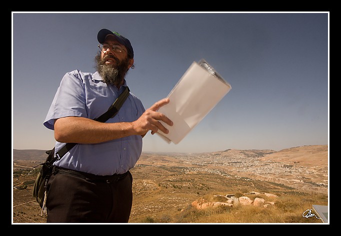
| ... v ruce má fotku z roku 1948, jak vypadal v Šechemu Josefův hrob - tam se taky dneska dostaneme ... :) |
| 2 GPS 29. 06. 2010 09:33:17, Izrael - Elon More, 1/200 sec, f 18, ISO 400 , 10 mm, Blesk Compulsory Flash |
Cesta
2010/06 cerven/29 Samari a Shekem-Nablus/20100629-016.jpgContains Exchangeable Image File Format (EXIF) Information
Main Image Information
| Image Width | 682 pixels |
| Image Length | 472 pixels |
| Compression | Uncompressed |
| Photometric Interpretation | RGB (Red Green Blue) |
| Make (Manufacturer) | Canon |
| Model | Canon EOS 40D |
| X Resolution | 1207959552/16777216 (72) pixels per 'Resolution Unit' |
| Y Resolution | 1207959552/16777216 (72) pixels per 'Resolution Unit' |
| Planar Configuration | Chunky Format |
| Resolution Unit | Inches |
| Date and Time | 2010:07:09 12:07:52 (Format: YYYY:MM:DD HH:mm:SS) |
| YCbCr Positioning | Chrominance components Centred in relation to luminance components |
EXIF Image File Directory (IFD) contents
| Exposure Time | 1/200 (0.005) seconds |
| Aperture F Number | 18/1 (18) |
| Exposure Program | Shutter priority |
| ISO Speed Ratings | 400 |
| Exif Version | 0221 |
| Date and Time of Original | 2010:06:29 09:33:17 |
| Date and Time when Digitized | 2010:06:29 09:33:17 |
| APEX Shutter Speed Value (Tv) | 7643856/1000000 (7.643856) |
| APEX Aperture Value (Av) | 833985/100000 (8.33985) |
| APEX Exposure Bias Value (Exposure Compensation) | 0/1 (0) EV |
| Metering Mode | Pattern |
| Flash | Flash fired, compulsory flash mode |
| FocalLength | 10/1 (10) mm |
| Sub Second Time of Original | 00 |
| Sub Second Time when Digitized | 00 |
| Focal Plane X Resolution | 3888000/876 (4438.3561643836) pixels per 'Focal Plane Resolution Unit' |
| Focal Plane Y Resolution | 2592000/583 (4445.9691252144) pixels per 'Focal Plane Resolution Unit' |
| Focal Plane Resolution Unit | Inches |
| Special Processing (Custom Rendered) | Normal process |
| Exposure Mode | Auto exposure |
| White Balance | Manual white balance |
| Scene Capture Type | Standard |
| Pixel X Dimension | 682 pixels |
| Pixel Y Dimension | 472 pixels |
| Colour Space | Uncalibrated |
| Components Configuration | Component 1: Y (Luminance) Component 2: Cb (Chroma minus Blue) Component 3: Cr (Chroma minus Red) Component 4: Does not exist |
| User Comment |
GPS Info Image File Directory (IFD) contents
| Longitude | 35/1 (35), 1960722/100000 (19.60722), 0/0 (Degrees Minutes Seconds East or West) |
| East or West Longitude | E |
| Latitude | 32/1 (32), 1447272/100000 (14.47272), 0/0 (Degrees Minutes Seconds North or South) |
| North or South Latitude | N |
| Altitude | 735070/1000 (735.07) Metres with respect to Altitude Reference |
| Altitude Reference | Sea Level |
Contains Extensible Metadata Platform (XMP) / Resource Description Framework (RDF) Information
Dublin Core Metadata Initiative RDF Segment
| Creator(s) (Authors): | Ordered List: Ing. Daniel Žingor |
| Rights Statement: | List of Alternates: © Daniel Žingor |
| Subject and Keywords: | Unordered List: Portrét Reportáž Web |
| Description (Caption): | List of Alternates: ... v ruce má fotku z roku 1948, jak vypadal v Šechemu Josefův hrob - tam se taky dneska dostaneme ... :) |
XMP - embedded TIFF Segment
| Make: | Canon |
| Model: | Canon EOS 40D |
| Image Width: | 3888 |
| Image Length: | 2592 |
| Samples Per Pixel: | 3 |
| Bits Per Sample: | Ordered List: 16 16 16 |
| Photometric Interpretation: | 2 |
XMP - embedded EXIF Segment
| Exif Version: | 0221 |
| Exposure Time: | 1/200 |
| Shutter Speed Value: | 7643856/1000000 |
| F Number: | 18/1 |
| Aperture Value: | 833985/100000 |
| Exposure Program: | 4 |
| Date & Time of Original: | 2010-06-29T09:33:17.00+02:00 |
| Date & Time Digitized: | 2010-06-29T09:33:17.00+02:00 |
| Exposure Bias Value: | 0/1 |
| Metering Mode: | 5 |
| Focal Length: | 10/1 |
| Custom Rendered: | 0 |
| Exposure Mode: | 0 |
| White Balance: | 1 |
| Scene Capture Type: | 0 |
| Focal Plane X Resolution: | 3888000/876 |
| Focal Plane Y Resolution: | 2592000/583 |
| Focal Plane Resolution Unit: | 2 |
| ISO Speed Ratings: | Ordered List: 400 |
| Flash: | Fired = True Return = 0 Mode = 1 Function = False Red Eye Mode = False |
| Pixel X Dimension: | 3888 |
| Pixel Y Dimension: | 2592 |
| GPS Longitude: | 35,19.607220E |
| GPS Latitude: | 32,14.472720N |
| GPS Altitude: | 735070/1000 |
| GPS Altitude Reference: | 0 |
XMP Basic Segment
| Resource Last Modify Date: | 2010-06-29T18:20:04+02:00 |
| Original Creation Date: | 2010-06-29T09:33:17.00+02:00 |
| Unknown field xap:Rating: | 2 |
| Unknown field xap:Label: | Green |
Unknown RDF Segment 'aux'
| Unknown field aux:Lens: | 10.00 - 20.00 mm |
| Unknown field aux:Firmware: | Firmware Version 1.0.3 |
Photoshop RDF Segment
| Unknown field photoshop:LegacyIPTCDigest: | EA20940AFBF52D322CB867DF2CB70E1C |
Unknown RDF Segment 'znr'
| Unknown field znr:RawDevelopSettings: | UEsDBBQAAAAIAHyS3TzLwME2zgIAAGcJAAAMAAAAc2V0dGluZ3MueG1sbZZLbtswEIb3BXqHHqBO ZCdxHggIBO2+QLvNhqHGFhGJFIaUXfsmPURP0EUXRc/TK5SShk/FK803/wzF4XDkf79+P57x+FDD AVrds/fvJvOpReD16anvWwk1Wz9evkFJa1D03Dbs88NzrV+HDpQ9PX95QX5+PT1vqnW1qrarzf2H b7zjf3/8+Tmxaru5X1Xr7cWnr5s5uU9DWTlauePC7mRrARmJCkraVu4ba1g1a8jyb9fwWh+D05vk FVpZ5MZ6d7C9v+Uo7Sm4ySSvha4H5HZAYNvbO6pSSn0a3qXUZ8upTyqVZas7yjUaSZLRTKITrxmT cCu1Yq66tNnISHWQ7lyUgKgJhBTNEN5vfCR6fPHQPRHbaey4ZVczJ4t8NXTacCl8VLBD3VuNpuci FiMSn1+24DqSqkoW+QbTGYug9q5htpQhZVGGvJaDYeuLTZQRiyLbIJhGt7Xvs4xFXTt0WrUn/04J IQ1874XuelZd+Pp6QgKFLsLveTaCx5UgekYjtjD2CkzaxAR8uUXPqNAiLOUaWZnxWHxYBKRAbbmF 6WVJQsSfEuoeQdhZ4X4fw8O6fKBT9BGhD4ydbrVvAzJjCwmoFe+AhS7yILvb1p/FdXbJbXFEdLsX 6pJnuV9aULWRZ2C3WfLI8+xL/cJR5B+wlm5L48S6KpZIXOUqb0S95cvWcgMBlBlH1PVNulDk+SpL /cKR5YcD22QHHnCed6GL3HenViAGPPiTj3Y2Ihq5syydEBMgyR75Cd2HyJfH24l7jwCK3dxHwUwS iaumm4frqJhAEOihd3dYm3FEB1EKU6WbjqkmDsvJnHaQCWay0My7rEphsXmH4yRIsy7mw0RjhVPt ou4TVVoacKUcxPxFSQIKV7ZCGDDZCuXYoQ2pA6Apsyc4U7tmR96jHj8DeUDmSWOaGvM/BgUttMUf hRKn6rFJjOAtZOJInfYy/1P1H1BLAQIAABQAAAAIAHyS3TzLwME2zgIAAGcJAAAMAAAAAAAAAAEA IAAAAAAAAABzZXR0aW5ncy54bWxQSwUGAAAAAAEAAQA6AAAA+AIAAAAA |
Unknown RDF Segment 'Iptc4xmpCore'
| Unknown field Iptc4xmpCore:Location: | Izrael - Elon More |


