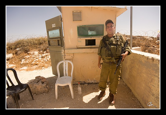
| Pořád se motáme kolem toho vojenského stanoviště - taky je tady vidět, co už jsem psal - hulí tady každý :) |
| 2 GPS 29. 06. 2010 10:30:45, Izrael - Elon More, 1/250 sec, f 10, ISO 200 , 11 mm, Blesk No Flash |
Cesta
2010/06 cerven/29 Samari a Shekem-Nablus/20100629-035.jpgContains Exchangeable Image File Format (EXIF) Information
Main Image Information
| Image Width | 682 pixels |
| Image Length | 472 pixels |
| Compression | Uncompressed |
| Photometric Interpretation | RGB (Red Green Blue) |
| Make (Manufacturer) | Canon |
| Model | Canon EOS 40D |
| X Resolution | 1207959552/16777216 (72) pixels per 'Resolution Unit' |
| Y Resolution | 1207959552/16777216 (72) pixels per 'Resolution Unit' |
| Planar Configuration | Chunky Format |
| Resolution Unit | Inches |
| Date and Time | 2010:07:09 12:08:02 (Format: YYYY:MM:DD HH:mm:SS) |
| YCbCr Positioning | Chrominance components Centred in relation to luminance components |
EXIF Image File Directory (IFD) contents
| Exposure Time | 1/250 (0.004) seconds |
| Aperture F Number | 10/1 (10) |
| Exposure Program | Aperture priority |
| ISO Speed Ratings | 200 |
| Exif Version | 0221 |
| Date and Time of Original | 2010:06:29 10:30:45 |
| Date and Time when Digitized | 2010:06:29 10:30:45 |
| APEX Shutter Speed Value (Tv) | 7965784/1000000 (7.965784) |
| APEX Aperture Value (Av) | 6643856/1000000 (6.643856) |
| APEX Exposure Bias Value (Exposure Compensation) | 0/1 (0) EV |
| Metering Mode | Pattern |
| Flash | Flash did not fire, compulsory flash suppression mode |
| FocalLength | 11/1 (11) mm |
| Sub Second Time of Original | 47 |
| Sub Second Time when Digitized | 47 |
| Focal Plane X Resolution | 3888000/876 (4438.3561643836) pixels per 'Focal Plane Resolution Unit' |
| Focal Plane Y Resolution | 2592000/583 (4445.9691252144) pixels per 'Focal Plane Resolution Unit' |
| Focal Plane Resolution Unit | Inches |
| Special Processing (Custom Rendered) | Normal process |
| Exposure Mode | Auto exposure |
| White Balance | Manual white balance |
| Scene Capture Type | Standard |
| Pixel X Dimension | 682 pixels |
| Pixel Y Dimension | 472 pixels |
| Colour Space | Uncalibrated |
| Components Configuration | Component 1: Y (Luminance) Component 2: Cb (Chroma minus Blue) Component 3: Cr (Chroma minus Red) Component 4: Does not exist |
| User Comment |
GPS Info Image File Directory (IFD) contents
| Longitude | 35/1 (35), 1961532/100000 (19.61532), 0/0 (Degrees Minutes Seconds East or West) |
| East or West Longitude | E |
| Latitude | 32/1 (32), 1448640/100000 (14.4864), 0/0 (Degrees Minutes Seconds North or South) |
| North or South Latitude | N |
| Altitude | 752850/1000 (752.85) Metres with respect to Altitude Reference |
| Altitude Reference | Sea Level |
Contains Extensible Metadata Platform (XMP) / Resource Description Framework (RDF) Information
Dublin Core Metadata Initiative RDF Segment
| Creator(s) (Authors): | Ordered List: Ing. Daniel Žingor |
| Rights Statement: | List of Alternates: © Daniel Žingor |
| Subject and Keywords: | Unordered List: Portrét Reportáž Web |
| Description (Caption): | List of Alternates: Pořád se motáme kolem toho vojenského stanoviště - taky je tady vidět, co už jsem psal - hulí tady každý :) |
XMP - embedded TIFF Segment
| Make: | Canon |
| Model: | Canon EOS 40D |
| Image Width: | 3888 |
| Image Length: | 2592 |
| Samples Per Pixel: | 3 |
| Bits Per Sample: | Ordered List: 16 16 16 |
| Photometric Interpretation: | 2 |
XMP - embedded EXIF Segment
| Exif Version: | 0221 |
| Exposure Time: | 1/250 |
| Shutter Speed Value: | 7965784/1000000 |
| F Number: | 10/1 |
| Aperture Value: | 6643856/1000000 |
| Exposure Program: | 3 |
| Date & Time of Original: | 2010-06-29T10:30:45.47+02:00 |
| Date & Time Digitized: | 2010-06-29T10:30:45.47+02:00 |
| Exposure Bias Value: | 0/1 |
| Metering Mode: | 5 |
| Focal Length: | 11/1 |
| Custom Rendered: | 0 |
| Exposure Mode: | 0 |
| White Balance: | 1 |
| Scene Capture Type: | 0 |
| Focal Plane X Resolution: | 3888000/876 |
| Focal Plane Y Resolution: | 2592000/583 |
| Focal Plane Resolution Unit: | 2 |
| ISO Speed Ratings: | Ordered List: 200 |
| Flash: | Fired = False Return = 0 Mode = 2 Function = False Red Eye Mode = False |
| Pixel X Dimension: | 3888 |
| Pixel Y Dimension: | 2592 |
| GPS Longitude: | 35,19.615320E |
| GPS Latitude: | 32,14.486400N |
| GPS Altitude: | 752850/1000 |
| GPS Altitude Reference: | 0 |
XMP Basic Segment
| Resource Last Modify Date: | 2010-06-29T18:24:37+02:00 |
| Original Creation Date: | 2010-06-29T10:30:45.47+02:00 |
| Unknown field xap:Rating: | 2 |
| Unknown field xap:Label: | Green |
Unknown RDF Segment 'aux'
| Unknown field aux:Lens: | 10.00 - 20.00 mm |
| Unknown field aux:Firmware: | Firmware Version 1.0.3 |
Photoshop RDF Segment
| Unknown field photoshop:LegacyIPTCDigest: | EA20940AFBF52D322CB867DF2CB70E1C |
Unknown RDF Segment 'znr'
| Unknown field znr:RawDevelopSettings: | UEsDBBQAAAAIAA+T3Tx0nxpk5gIAAKsJAAAMAAAAc2V0dGluZ3MueG1sbZZLbtswEIb3BXqHHiBO ZDt2miAgELT7Au02G4YaW0QkUhhSTp2b9BA9QRddFD1Pr1BKGj4VAwY03/wcksPhSP9+/b5/xZe7 Gk7Q6p69fzeZDy0Cr88Pfd9KqNn6/uoNSlqDoue2YZ/vHmv9PHSg7PnxyxPy1+fz46ZaV6tqv9rc fvjGO/73x5+fE6v2m9tVtd1dfvq6mYP7MBSVo5UHLuxBthaQkaigpG3lsbGGVbOGLL+6htf6JTi9 SV6hlUVurHcH2/tbjtKeg5tM8lroekBuBwS2v9nuZlFKfRjepdRHy6kPKpVlqxuKNRpJkNFMRide MwbhVmrFXHZps5GR6iTduSgBURMIKZohrG98JPry5KF7InbQ2HHLtjMni3w1dNpwKfyoYIe8txpN z0VMRiQ+vmzBVSTVHlnkG0xnLII6uoLZU4SURRnyWg6GrS83UUYsimyDYBrd1r7OMhZ17dBp1Z79 mhJCGvjeC931rLr0+fWEBArdCL/n2Qgel4LoGY1YwtgrMGkRE/DpFj2jRIswlStkZcZj8cMiIAVq yy1MiyUJEX9KqHsEYWeF+12Eh3X5QKfoR4Q6MHa61b4MyIwlJKBWvAMWqsiD7G5bfxbX2SW3xRHR 7V6oS57FfmpB1Ua+ArvJgkeeR1/qF44i/oC1dFsaO9a2mCJxlbO8MeotXzaXawigzNiirnfpRJHn syz1C0cWH05skx14wHnchS5yX51agRjw5E5+MkWvx2728cIXKwEvJ3Oz2124/0JzlcfM2kwjD5al XWYCJDkiP6N7mfkUeztxHxFAsd1tFMwkkbgTcT11HRUTCAI99K4PaDO2+SBKYap0HTbVxIY7mdMO MsFMFpp5l1UpLDbvcOwmadRFj5lozHCqXeR9okpLAy6Vg5jfSsmAwpXNEJpUNkPZumhD6gRoyugJ ztTuwiDvUY+vknxA5knHNDXmHxcFLbTFx0aJU/VYJEbwFjJxpL6m44fZf1BLAQIAABQAAAAIAA+T 3Tx0nxpk5gIAAKsJAAAMAAAAAAAAAAEAIAAAAAAAAABzZXR0aW5ncy54bWxQSwUGAAAAAAEAAQA6 AAAAEAMAAAAA |
Unknown RDF Segment 'Iptc4xmpCore'
| Unknown field Iptc4xmpCore:Location: | Izrael - Elon More |


