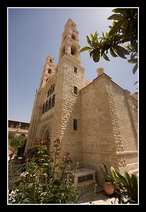
| Z tohoto pohledu se daleko raději držím toho, co Izraelci považují za doložená historická místa a toto je jedno z nich ... |
| 3 GPS 29. 06. 2010 11:09:25, Izrael - Shekem (Nablus), 1/500 sec, f 8, ISO 200 , 10 mm, Blesk No Flash |
Cesta
2010/06 cerven/29 Samari a Shekem-Nablus/20100629-043.jpgContains Exchangeable Image File Format (EXIF) Information
Main Image Information
| Image Width | 472 pixels |
| Image Length | 682 pixels |
| Compression | Uncompressed |
| Photometric Interpretation | RGB (Red Green Blue) |
| Make (Manufacturer) | Canon |
| Model | Canon EOS 40D |
| X Resolution | 1207959552/16777216 (72) pixels per 'Resolution Unit' |
| Y Resolution | 1207959552/16777216 (72) pixels per 'Resolution Unit' |
| Planar Configuration | Chunky Format |
| Resolution Unit | Inches |
| Date and Time | 2010:07:09 12:08:30 (Format: YYYY:MM:DD HH:mm:SS) |
| YCbCr Positioning | Chrominance components Centred in relation to luminance components |
EXIF Image File Directory (IFD) contents
| Exposure Time | 1/500 (0.002) seconds |
| Aperture F Number | 8/1 (8) |
| Exposure Program | Aperture priority |
| ISO Speed Ratings | 200 |
| Exif Version | 0221 |
| Date and Time of Original | 2010:06:29 11:09:25 |
| Date and Time when Digitized | 2010:06:29 11:09:25 |
| APEX Shutter Speed Value (Tv) | 8965784/1000000 (8.965784) |
| APEX Aperture Value (Av) | 6/1 (6) |
| APEX Exposure Bias Value (Exposure Compensation) | 0/1 (0) EV |
| Metering Mode | Pattern |
| Flash | Flash did not fire, compulsory flash suppression mode |
| FocalLength | 10/1 (10) mm |
| Sub Second Time of Original | 01 |
| Sub Second Time when Digitized | 01 |
| Focal Plane X Resolution | 3888000/876 (4438.3561643836) pixels per 'Focal Plane Resolution Unit' |
| Focal Plane Y Resolution | 2592000/583 (4445.9691252144) pixels per 'Focal Plane Resolution Unit' |
| Focal Plane Resolution Unit | Inches |
| Special Processing (Custom Rendered) | Normal process |
| Exposure Mode | Auto exposure |
| White Balance | Manual white balance |
| Scene Capture Type | Standard |
| Pixel X Dimension | 472 pixels |
| Pixel Y Dimension | 682 pixels |
| Colour Space | Uncalibrated |
| Components Configuration | Component 1: Y (Luminance) Component 2: Cb (Chroma minus Blue) Component 3: Cr (Chroma minus Red) Component 4: Does not exist |
| User Comment |
GPS Info Image File Directory (IFD) contents
| Longitude | 35/1 (35), 1709827/100000 (17.09827), 0/0 (Degrees Minutes Seconds East or West) |
| East or West Longitude | E |
| Latitude | 32/1 (32), 1257018/100000 (12.57018), 0/0 (Degrees Minutes Seconds North or South) |
| North or South Latitude | N |
| Altitude | 513000/1000 (513) Metres with respect to Altitude Reference |
| Altitude Reference | Sea Level |
Contains Extensible Metadata Platform (XMP) / Resource Description Framework (RDF) Information
Dublin Core Metadata Initiative RDF Segment
| Creator(s) (Authors): | Ordered List: Ing. Daniel Žingor |
| Rights Statement: | List of Alternates: © Daniel Žingor |
| Subject and Keywords: | Unordered List: Architektura Reportáž Web |
| Description (Caption): | List of Alternates: Z tohoto pohledu se daleko raději držím toho, co Izraelci považují za doložená historická místa a toto je jedno z nich ... |
XMP - embedded TIFF Segment
| Make: | Canon |
| Model: | Canon EOS 40D |
| Image Width: | 2592 |
| Image Length: | 3888 |
| Samples Per Pixel: | 3 |
| Bits Per Sample: | Ordered List: 16 16 16 |
| Photometric Interpretation: | 2 |
XMP - embedded EXIF Segment
| Exif Version: | 0221 |
| Exposure Time: | 1/500 |
| Shutter Speed Value: | 8965784/1000000 |
| F Number: | 8/1 |
| Aperture Value: | 6/1 |
| Exposure Program: | 3 |
| Date & Time of Original: | 2010-06-29T11:09:25.01+02:00 |
| Date & Time Digitized: | 2010-06-29T11:09:25.01+02:00 |
| Exposure Bias Value: | 0/1 |
| Metering Mode: | 5 |
| Focal Length: | 10/1 |
| Custom Rendered: | 0 |
| Exposure Mode: | 0 |
| White Balance: | 1 |
| Scene Capture Type: | 0 |
| Focal Plane X Resolution: | 3888000/876 |
| Focal Plane Y Resolution: | 2592000/583 |
| Focal Plane Resolution Unit: | 2 |
| ISO Speed Ratings: | Ordered List: 200 |
| Flash: | Fired = False Return = 0 Mode = 2 Function = False Red Eye Mode = False |
| Pixel X Dimension: | 2592 |
| Pixel Y Dimension: | 3888 |
| GPS Longitude: | 35,17.098270E |
| GPS Latitude: | 32,12.570180N |
| GPS Altitude: | 513000/1000 |
| GPS Altitude Reference: | 0 |
XMP Basic Segment
| Resource Last Modify Date: | 2010-06-29T18:26:25+02:00 |
| Original Creation Date: | 2010-06-29T11:09:25.01+02:00 |
| Unknown field xap:Rating: | 3 |
| Unknown field xap:Label: | Green |
Unknown RDF Segment 'aux'
| Unknown field aux:Lens: | 10.00 - 20.00 mm |
| Unknown field aux:Firmware: | Firmware Version 1.0.3 |
Photoshop RDF Segment
| Unknown field photoshop:LegacyIPTCDigest: | EA20940AFBF52D322CB867DF2CB70E1C |
Unknown RDF Segment 'znr'
| Unknown field znr:RawDevelopSettings: | UEsDBBQAAAAIAEmT3TzXdgNMzgIAAGcJAAAMAAAAc2V0dGluZ3MueG1sbZZLbtwwDIb3BXqHHqCT eiavJggEBO2+QLvNRpE5YyG2JFDypJOb9BA9QRddFD1Pr1DZpp7OrMyfHymLouj59+v33Qs+37Zw hF4b9vbNbN73CLw93RvTS2jZ9u7DKyqxFoXhrmOfbx9a/TQOoNzp4csj8pen08Ou2Tab5mqzu3n3 jQ/8748/P2etudrdbJqL87NPX3dL8pCGsnJ0cs+F28veATKCKpXYXh46Z1mzMGSFt+t4q5+jM5jk FVo55NYFd7SDv+co3Sm6ySSvg8EAcjcisMvr6/MFytWQhg+5GrKVakgqlWObj5RrMrIkk5lFZ147 JeFOasV8dWmzSSPqKP25KAGJiQoR3Rjfb3ok9fkxiP6JtL3GgTtGuyaLfC0M2nIpQlS0Y917jdZw kYqRlJBf9uA7knqPLPKNdrAOQR18w1xRhlxLGPJWjpZtz3YJIy1BrkOwne7b0GeFlrh+HLTqT+Gd MoUY+G6EHgxrzkJ9g0KAQh8R9rwY0eNLkDyTkVoYjQKbNzEJodzCMCq0iEv5RlZ2OpYQlgQiUDvu YH5ZQkgJp4TaIAi3EP73Pj5s6wc6xRAR+8C6+VaHNiAztZCAVvEBWOyiIBR324WzuCguuauOiG73 iq71IvdjD6q18gXYdZE86WX2Nb9yVPlHbKXf0jSxzqslMle9yitRr/mKtfxAAGWnEXVxmS+U9HKV Nb9yFPnhyHbFgUe5zLvikh66UysQIx7DySe7GBGd3DuWT4hZIOSA/IT+QxTKE+zMfUAAxS5vErAo GeKr6efhNhGzEAE9Gn+HtZ1GdIRyMSf9dMyZNCxnc95BASzKill22dRgtXkvp0mQZ13Nh1lNFc7Z Vd1nVWlpwZdyFMsXJQuoXMUKccAUK9RjhzakjoC2zp7JBe2bHblBPX0GyoDCk8d0LZZ/DCq1Yqs/ CrWc01OTWMF7KOCkevZD+afqP1BLAQIAABQAAAAIAEmT3TzXdgNMzgIAAGcJAAAMAAAAAAAAAAEA IAAAAAAAAABzZXR0aW5ncy54bWxQSwUGAAAAAAEAAQA6AAAA+AIAAAAA |
Unknown RDF Segment 'Iptc4xmpCore'
| Unknown field Iptc4xmpCore:Location: | Izrael - Shekem (Nablus) |


