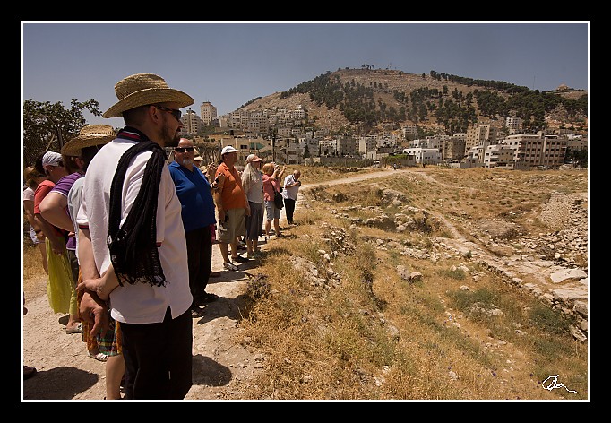
| A tak ten, kdo plésá a jásá je Dan Haslinger - to, že někdy uvidí vykopávky původního Šechemu se mu prý ani nezdálo - jen je prý kdesi na internetu někdy viděl, že se prý opravdu dělaly. Mezi námi pro ostatní je to hromada sutin :). |
| 3 GPS 29. 06. 2010 11:40:49, Izrael - Shekem (Nablus), 1/250 sec, f 14, ISO 200 , 11 mm, Blesk No Flash |
Cesta
2010/06 cerven/29 Samari a Shekem-Nablus/20100629-060.jpgContains Exchangeable Image File Format (EXIF) Information
Main Image Information
| Image Width | 682 pixels |
| Image Length | 472 pixels |
| Compression | Uncompressed |
| Photometric Interpretation | RGB (Red Green Blue) |
| Make (Manufacturer) | Canon |
| Model | Canon EOS 40D |
| X Resolution | 1207959552/16777216 (72) pixels per 'Resolution Unit' |
| Y Resolution | 1207959552/16777216 (72) pixels per 'Resolution Unit' |
| Planar Configuration | Chunky Format |
| Resolution Unit | Inches |
| Date and Time | 2010:07:09 12:08:11 (Format: YYYY:MM:DD HH:mm:SS) |
| YCbCr Positioning | Chrominance components Centred in relation to luminance components |
EXIF Image File Directory (IFD) contents
| Exposure Time | 1/250 (0.004) seconds |
| Aperture F Number | 14/1 (14) |
| Exposure Program | Aperture priority |
| ISO Speed Ratings | 200 |
| Exif Version | 0221 |
| Date and Time of Original | 2010:06:29 11:40:49 |
| Date and Time when Digitized | 2010:06:29 11:40:49 |
| APEX Shutter Speed Value (Tv) | 7965784/1000000 (7.965784) |
| APEX Aperture Value (Av) | 761471/100000 (7.61471) |
| APEX Exposure Bias Value (Exposure Compensation) | 0/1 (0) EV |
| Metering Mode | Pattern |
| Flash | Flash did not fire, compulsory flash suppression mode |
| FocalLength | 11/1 (11) mm |
| Sub Second Time of Original | 16 |
| Sub Second Time when Digitized | 16 |
| Focal Plane X Resolution | 3888000/876 (4438.3561643836) pixels per 'Focal Plane Resolution Unit' |
| Focal Plane Y Resolution | 2592000/583 (4445.9691252144) pixels per 'Focal Plane Resolution Unit' |
| Focal Plane Resolution Unit | Inches |
| Special Processing (Custom Rendered) | Normal process |
| Exposure Mode | Auto exposure |
| White Balance | Manual white balance |
| Scene Capture Type | Standard |
| Pixel X Dimension | 682 pixels |
| Pixel Y Dimension | 472 pixels |
| Colour Space | Uncalibrated |
| Components Configuration | Component 1: Y (Luminance) Component 2: Cb (Chroma minus Blue) Component 3: Cr (Chroma minus Red) Component 4: Does not exist |
| User Comment |
GPS Info Image File Directory (IFD) contents
| Longitude | 35/1 (35), 1695877/100000 (16.95877), 0/0 (Degrees Minutes Seconds East or West) |
| East or West Longitude | E |
| Latitude | 32/1 (32), 1280958/100000 (12.80958), 0/0 (Degrees Minutes Seconds North or South) |
| North or South Latitude | N |
| Altitude | 533670/1000 (533.67) Metres with respect to Altitude Reference |
| Altitude Reference | Sea Level |
Contains Extensible Metadata Platform (XMP) / Resource Description Framework (RDF) Information
Dublin Core Metadata Initiative RDF Segment
| Creator(s) (Authors): | Ordered List: Ing. Daniel Žingor |
| Rights Statement: | List of Alternates: © Daniel Žingor |
| Subject and Keywords: | Unordered List: Reportáž Web |
| Description (Caption): | List of Alternates: A tak ten, kdo plésá a jásá je Dan Haslinger - to, že někdy uvidí vykopávky původního Šechemu se mu prý ani nezdálo - jen je prý kdesi na internetu někdy viděl, že se prý opravdu dělaly. Mezi námi pro ostatní je to hromada sutin :). |
XMP - embedded TIFF Segment
| Make: | Canon |
| Model: | Canon EOS 40D |
| Image Width: | 3888 |
| Image Length: | 2592 |
| Samples Per Pixel: | 3 |
| Bits Per Sample: | Ordered List: 16 16 16 |
| Photometric Interpretation: | 2 |
XMP - embedded EXIF Segment
| Exif Version: | 0221 |
| Exposure Time: | 1/250 |
| Shutter Speed Value: | 7965784/1000000 |
| F Number: | 14/1 |
| Aperture Value: | 761471/100000 |
| Exposure Program: | 3 |
| Date & Time of Original: | 2010-06-29T11:40:49.16+02:00 |
| Date & Time Digitized: | 2010-06-29T11:40:49.16+02:00 |
| Exposure Bias Value: | 0/1 |
| Metering Mode: | 5 |
| Focal Length: | 11/1 |
| Custom Rendered: | 0 |
| Exposure Mode: | 0 |
| White Balance: | 1 |
| Scene Capture Type: | 0 |
| Focal Plane X Resolution: | 3888000/876 |
| Focal Plane Y Resolution: | 2592000/583 |
| Focal Plane Resolution Unit: | 2 |
| ISO Speed Ratings: | Ordered List: 200 |
| Flash: | Fired = False Return = 0 Mode = 2 Function = False Red Eye Mode = False |
| Pixel X Dimension: | 3888 |
| Pixel Y Dimension: | 2592 |
| GPS Longitude: | 35,16.958771E |
| GPS Latitude: | 32,12.809580N |
| GPS Altitude: | 533670/1000 |
| GPS Altitude Reference: | 0 |
XMP Basic Segment
| Resource Last Modify Date: | 2010-06-29T18:30:39+02:00 |
| Original Creation Date: | 2010-06-29T11:40:49.16+02:00 |
| Unknown field xap:Rating: | 3 |
| Unknown field xap:Label: | Green |
Unknown RDF Segment 'aux'
| Unknown field aux:Lens: | 10.00 - 20.00 mm |
| Unknown field aux:Firmware: | Firmware Version 1.0.3 |
Photoshop RDF Segment
| Unknown field photoshop:LegacyIPTCDigest: | EA20940AFBF52D322CB867DF2CB70E1C |
Unknown RDF Segment 'znr'
| Unknown field znr:RawDevelopSettings: | UEsDBBQAAAAIANCT3Tz+BwIKzAIAAGcJAAAMAAAAc2V0dGluZ3MueG1sbZZLbtwwDIb3BXqHHqBJ PJN3EAgI2n2BdpuNInPGQmTJoORJJzfpIXqCLrooep5eobJNPZ1ZmR9/UhZF0fPv1+/7V3y5a+EA ygzs/bvZfFAIvD0+DIOS0LLN/dkblLQWxcBdxz7fPbbmeexBu+Pjlyfkr8/Hx22zaU6aq5Pt7Ydv vOd/f/z5ObPmanvreXP66et2SR7SUFaOTu64cDupHCAjUUVJq+S+c5Y1i4as8HYdb81LdAaTvMJo h9y64I528CuO0h2jm0zyOugHQO5GBHZ5fX2+iHIa0vA+pyFbSUNSqR07uaFck5ElmcwsOvPaKQl3 0mjmq0ubTYxUB+nPRQtImkhI0Y3x/aZHoi9PAfonYjuDPXeMdk0W+VrojeVShKhox7org3bgIhUj kZBfKvAdSb1HFvlG21uHoPe+Ya4oQ86SDHkrR8s2p9skI5ZErkOwnVFt6LOCJZ0ae6PVMbxTRkgD 3wdh+oE1p6G+gZBAo48Ie16M6PElSJ7JSC2MgwabNzGBUG4xMCq0iEv5RtZ2OpYQlgAp0DjuYH5Z khAJp4RmQBBuUfjfx/iwqR/oFENE7APr5lsd2oDM1EICWs17YLGLAijutgtncVFcclcdEd3ulbrm Re4nBbq18hXYdZE88TL7Wr9yVPlHbKXf0jSxzqslMle9yhtRb/mKtfxAAG2nEXVxmS+UeLnKWr9y FPnhwLbFgUdc5l3pEg/daTSIEQ/h5JNdjIhO7hzLJ8QMSLJHfkT/IQrlCXbm3iOAZpe3SbCQTOKr 6efhJilmEAVmHPwdNnYa0VGUw1zpp2OuScNyNucdFIKFrDTLLptaWG3e4zQJ8qyr+TDTVOFcu6r7 TLWRFnwpR7F8UbKAylWsEAdMsUI9dmhD+gBo6+wZLtS+2ZEPaKbPQBlQePKYrsXyj0FFK231R6HG uXpqEiu4gkKcqNeelX+q/gNQSwECAAAUAAAACADQk908/gcCCswCAABnCQAADAAAAAAAAAABACAA AAAAAAAAc2V0dGluZ3MueG1sUEsFBgAAAAABAAEAOgAAAPYCAAAAAA== |
Unknown RDF Segment 'Iptc4xmpCore'
| Unknown field Iptc4xmpCore:Location: | Izrael - Shekem (Nablus) |


