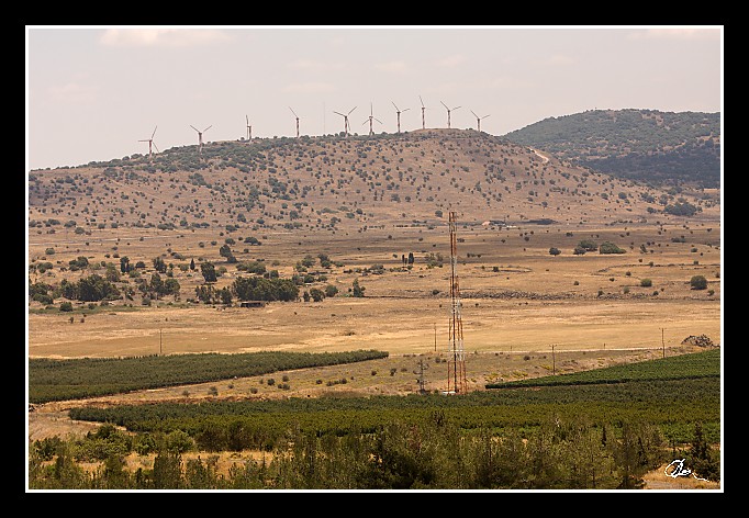
| Tady už se díváme na druhou stranu hranice - Sýrie ... |
| 3 GPS 27. 06. 2010 12:12:04, Izrael - Golany, 1/3200 sec, f 3.5, ISO 200 , 100 mm, Blesk No Flash |
Cesta
2010/06 cerven/27 Galilea, Golany a plavba/20100627-025.jpgContains Exchangeable Image File Format (EXIF) Information
Main Image Information
| Image Width | 682 pixels |
| Image Length | 472 pixels |
| Compression | Uncompressed |
| Photometric Interpretation | RGB (Red Green Blue) |
| Make (Manufacturer) | Canon |
| Model | Canon EOS 40D |
| X Resolution | 1207959552/16777216 (72) pixels per 'Resolution Unit' |
| Y Resolution | 1207959552/16777216 (72) pixels per 'Resolution Unit' |
| Planar Configuration | Chunky Format |
| Resolution Unit | Inches |
| Date and Time | 2010:07:08 10:31:26 (Format: YYYY:MM:DD HH:mm:SS) |
| YCbCr Positioning | Chrominance components Centred in relation to luminance components |
EXIF Image File Directory (IFD) contents
| Exposure Time | 1/3200 (0.0003125) seconds |
| Aperture F Number | 35/10 (3.5) |
| Exposure Program | Aperture priority |
| ISO Speed Ratings | 200 |
| Exif Version | 0221 |
| Date and Time of Original | 2010:06:27 12:12:04 |
| Date and Time when Digitized | 2010:06:27 12:12:04 |
| APEX Shutter Speed Value (Tv) | 11643856/1000000 (11.643856) |
| APEX Aperture Value (Av) | 361471/100000 (3.61471) |
| APEX Exposure Bias Value (Exposure Compensation) | 0/1 (0) EV |
| Metering Mode | Pattern |
| Flash | Flash did not fire, compulsory flash suppression mode |
| FocalLength | 100/1 (100) mm |
| Sub Second Time of Original | 00 |
| Sub Second Time when Digitized | 00 |
| Focal Plane X Resolution | 3888000/876 (4438.3561643836) pixels per 'Focal Plane Resolution Unit' |
| Focal Plane Y Resolution | 2592000/583 (4445.9691252144) pixels per 'Focal Plane Resolution Unit' |
| Focal Plane Resolution Unit | Inches |
| Special Processing (Custom Rendered) | Normal process |
| Exposure Mode | Auto exposure |
| White Balance | Manual white balance |
| Scene Capture Type | Standard |
| Pixel X Dimension | 682 pixels |
| Pixel Y Dimension | 472 pixels |
| Colour Space | Uncalibrated |
| Components Configuration | Component 1: Y (Luminance) Component 2: Cb (Chroma minus Blue) Component 3: Cr (Chroma minus Red) Component 4: Does not exist |
| User Comment |
GPS Info Image File Directory (IFD) contents
| Longitude | 35/1 (35), 4805513/100000 (48.05513), 0/0 (Degrees Minutes Seconds East or West) |
| East or West Longitude | E |
| Latitude | 33/1 (33), 649793/100000 (6.49793), 0/0 (Degrees Minutes Seconds North or South) |
| North or South Latitude | N |
| Altitude | 1000870/1000 (1000.87) Metres with respect to Altitude Reference |
| Altitude Reference | Sea Level |
Contains Extensible Metadata Platform (XMP) / Resource Description Framework (RDF) Information
Dublin Core Metadata Initiative RDF Segment
| Creator(s) (Authors): | Ordered List: Ing. Daniel Žingor |
| Rights Statement: | List of Alternates: © Daniel Žingor |
| Subject and Keywords: | Unordered List: Reportáž Krajina Web |
| Description (Caption): | List of Alternates: Tady už se díváme na druhou stranu hranice - Sýrie ... |
XMP - embedded TIFF Segment
| Make: | Canon |
| Model: | Canon EOS 40D |
| Image Width: | 3888 |
| Image Length: | 2592 |
| Samples Per Pixel: | 3 |
| Bits Per Sample: | Ordered List: 16 16 16 |
| Photometric Interpretation: | 2 |
XMP - embedded EXIF Segment
| Exif Version: | 0221 |
| Exposure Time: | 1/3200 |
| Shutter Speed Value: | 11643856/1000000 |
| F Number: | 35/10 |
| Aperture Value: | 361471/100000 |
| Exposure Program: | 3 |
| Date & Time of Original: | 2010-06-27T12:12:04.00+02:00 |
| Date & Time Digitized: | 2010-06-27T12:12:04.00+02:00 |
| Exposure Bias Value: | 0/1 |
| Metering Mode: | 5 |
| Focal Length: | 100/1 |
| Custom Rendered: | 0 |
| Exposure Mode: | 0 |
| White Balance: | 1 |
| Scene Capture Type: | 0 |
| Focal Plane X Resolution: | 3888000/876 |
| Focal Plane Y Resolution: | 2592000/583 |
| Focal Plane Resolution Unit: | 2 |
| ISO Speed Ratings: | Ordered List: 200 |
| Flash: | Fired = False Return = 0 Mode = 2 Function = False Red Eye Mode = False |
| Pixel X Dimension: | 3888 |
| Pixel Y Dimension: | 2592 |
| GPS Longitude: | 35,48.055130E |
| GPS Latitude: | 33,6.497930N |
| GPS Altitude: | 1000870/1000 |
| GPS Altitude Reference: | 0 |
XMP Basic Segment
| Resource Last Modify Date: | 2010-06-27T21:06:32+02:00 |
| Original Creation Date: | 2010-06-27T12:12:04.00+02:00 |
| Unknown field xap:Rating: | 3 |
| Unknown field xap:Label: | Green |
Unknown RDF Segment 'aux'
| Unknown field aux:Lens: | 70.00 - 200.00 mm |
| Unknown field aux:Firmware: | Firmware Version 1.0.3 |
Photoshop RDF Segment
| Unknown field photoshop:LegacyIPTCDigest: | EA20940AFBF52D322CB867DF2CB70E1C |
Unknown RDF Segment 'znr'
| Unknown field znr:RawDevelopSettings: | UEsDBBQAAAAIAM6o2zwb4DmX/AIAAAIKAAAMAAAAc2V0dGluZ3MueG1sfZZLbtswEIb3BXoHH8BO JDm2kSAgEKRAlgW6zoamaIsIRRIk5dS5Whc9Uq9QSho+FcQrzT8fZ8jhaOR/f/4+fuj3h5ZeKJcK ff82mU9cU9xen5TijLaofrz9RAXWaKKw7dCPh9dWvg09Ffb6+vOo8cfb9bWp6mpT7TfNYfWCOeMU r1cvkmNxXeGV4vhyxBNT7ZvDpmp2N8+/mjmZDwtZsLbshIk9MW6pRgAVKrCcnTtrUDUzYPnddriV 78HpTfASKazGxnp3sL2fY83sNbjBBK+lvaIa20FTtD9sdzOUqj4M7lPVR8tVH5QJizYHiDUaSZDR TFYnXjMGwZZJgVx14bBRA+rC3D0JQiMTFCC6IexvfAT1/ehF9wTaSeoeW7SddbDA19JeGsyIXxXs UHcutVGYxGJExcd33eM6FHoRLPANpjdWU3F2DbOHCKkWMY1bNhhU3zQRAy1CttPUdJK3vs8yLXJ8 6KXgV7+nRAGG/lZE9gpVN76+XgFAaLfCn3k2gseVIHpGI7awVoKatIlB8OUmCkGhSUjlGlmY8Vr8 sigAoaXFlk6bBQQUf0taKk2JnQn3W4eHunyAW/QrQh8YO73Vvg3AjC1EaCtwT1HoIi9k77b1d3GX veS2uCJ4uxd0qWexj5yK1rAPig5Z8Kjn0Zf8wlHEH3TL3JHGibUtUiSuMssnqz7zZbncQKDCjCPq bpcminqeZckvHFl8ekFNduFBzuMuuKj77pSCkkFf3M1PJlFynGZ1vfbdCornwdw3693dl0Rd36/r bfMl0zT1utntFsxtvrVsWnXsZFE6rCYBkLPGV+2+kf6mvJ24z5pSgXb3EZiVBHEX60ZzHYlJCIAc lBsn0oxfiwClYkq6QZ0ycW5P5nSCDJiVBTOfsirB4vBOjkMpjboYVZMaK5yyi7pPqpDMUFfKgcwf t2RB4coyhFmXZSgnIBxIXKg2ZfREzmj33mmstBy/SPmCzJOu6Vqd/0cp1IIt/rOUckqPTWII5jSD o+p7Ov7f+w9QSwECAAAUAAAACADOqNs8G+A5l/wCAAACCgAADAAAAAAAAAABACAAAAAAAAAAc2V0 dGluZ3MueG1sUEsFBgAAAAABAAEAOgAAACYDAAAAAA== |
Unknown RDF Segment 'Iptc4xmpCore'
| Unknown field Iptc4xmpCore:Location: | Izrael - Golany |


