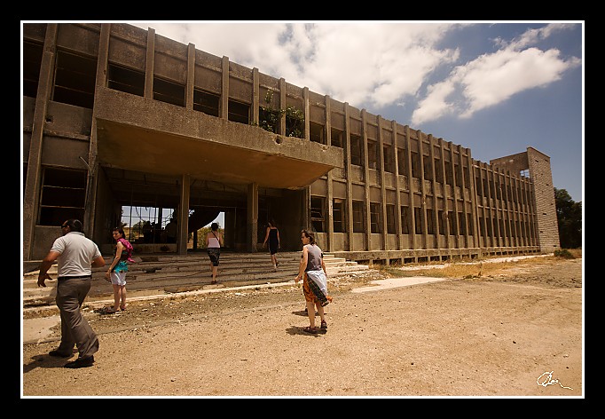
| A tady jedna z lahůdek CK Avetour! Opuštěná syrská kasárna! |
| 3 GPS 27. 06. 2010 12:25:03, Izrael - Golany, 1/2000 sec, f 4.5, ISO 200 , 10 mm, Blesk No Flash |
Cesta
2010/06 cerven/27 Galilea, Golany a plavba/20100627-029.jpgContains Exchangeable Image File Format (EXIF) Information
Main Image Information
| Image Width | 682 pixels |
| Image Length | 472 pixels |
| Compression | Uncompressed |
| Photometric Interpretation | RGB (Red Green Blue) |
| Make (Manufacturer) | Canon |
| Model | Canon EOS 40D |
| X Resolution | 1207959552/16777216 (72) pixels per 'Resolution Unit' |
| Y Resolution | 1207959552/16777216 (72) pixels per 'Resolution Unit' |
| Planar Configuration | Chunky Format |
| Resolution Unit | Inches |
| Date and Time | 2010:07:08 10:31:30 (Format: YYYY:MM:DD HH:mm:SS) |
| YCbCr Positioning | Chrominance components Centred in relation to luminance components |
EXIF Image File Directory (IFD) contents
| Exposure Time | 1/2000 (0.0005) seconds |
| Aperture F Number | 45/10 (4.5) |
| Exposure Program | Aperture priority |
| ISO Speed Ratings | 200 |
| Exif Version | 0221 |
| Date and Time of Original | 2010:06:27 12:25:03 |
| Date and Time when Digitized | 2010:06:27 12:25:03 |
| APEX Shutter Speed Value (Tv) | 10965784/1000000 (10.965784) |
| APEX Aperture Value (Av) | 433985/100000 (4.33985) |
| APEX Exposure Bias Value (Exposure Compensation) | 0/1 (0) EV |
| Metering Mode | Pattern |
| Flash | Flash did not fire, compulsory flash suppression mode |
| FocalLength | 10/1 (10) mm |
| Sub Second Time of Original | 02 |
| Sub Second Time when Digitized | 02 |
| Focal Plane X Resolution | 3888000/876 (4438.3561643836) pixels per 'Focal Plane Resolution Unit' |
| Focal Plane Y Resolution | 2592000/583 (4445.9691252144) pixels per 'Focal Plane Resolution Unit' |
| Focal Plane Resolution Unit | Inches |
| Special Processing (Custom Rendered) | Normal process |
| Exposure Mode | Auto exposure |
| White Balance | Manual white balance |
| Scene Capture Type | Standard |
| Pixel X Dimension | 682 pixels |
| Pixel Y Dimension | 472 pixels |
| Colour Space | Uncalibrated |
| Components Configuration | Component 1: Y (Luminance) Component 2: Cb (Chroma minus Blue) Component 3: Cr (Chroma minus Red) Component 4: Does not exist |
| User Comment |
GPS Info Image File Directory (IFD) contents
| Longitude | 35/1 (35), 4861433/100000 (48.61433), 0/0 (Degrees Minutes Seconds East or West) |
| East or West Longitude | E |
| Latitude | 33/1 (33), 792528/100000 (7.92528), 0/0 (Degrees Minutes Seconds North or South) |
| North or South Latitude | N |
| Altitude | 935020/1000 (935.02) Metres with respect to Altitude Reference |
| Altitude Reference | Sea Level |
Contains Extensible Metadata Platform (XMP) / Resource Description Framework (RDF) Information
Dublin Core Metadata Initiative RDF Segment
| Creator(s) (Authors): | Ordered List: Ing. Daniel Žingor |
| Rights Statement: | List of Alternates: © Daniel Žingor |
| Subject and Keywords: | Unordered List: Reportáž Architektura Web |
| Description (Caption): | List of Alternates: A tady jedna z lahůdek CK Avetour! Opuštěná syrská kasárna! |
XMP - embedded TIFF Segment
| Make: | Canon |
| Model: | Canon EOS 40D |
| Image Width: | 3888 |
| Image Length: | 2592 |
| Samples Per Pixel: | 3 |
| Bits Per Sample: | Ordered List: 16 16 16 |
| Photometric Interpretation: | 2 |
XMP - embedded EXIF Segment
| Exif Version: | 0221 |
| Exposure Time: | 1/2000 |
| Shutter Speed Value: | 10965784/1000000 |
| F Number: | 45/10 |
| Aperture Value: | 433985/100000 |
| Exposure Program: | 3 |
| Date & Time of Original: | 2010-06-27T12:25:03.02+02:00 |
| Date & Time Digitized: | 2010-06-27T12:25:03.02+02:00 |
| Exposure Bias Value: | 0/1 |
| Metering Mode: | 5 |
| Focal Length: | 10/1 |
| Custom Rendered: | 0 |
| Exposure Mode: | 0 |
| White Balance: | 1 |
| Scene Capture Type: | 0 |
| Focal Plane X Resolution: | 3888000/876 |
| Focal Plane Y Resolution: | 2592000/583 |
| Focal Plane Resolution Unit: | 2 |
| ISO Speed Ratings: | Ordered List: 200 |
| Flash: | Fired = False Return = 0 Mode = 2 Function = False Red Eye Mode = False |
| Pixel X Dimension: | 3888 |
| Pixel Y Dimension: | 2592 |
| GPS Longitude: | 35,48.614330E |
| GPS Latitude: | 33,7.925280N |
| GPS Altitude: | 935020/1000 |
| GPS Altitude Reference: | 0 |
XMP Basic Segment
| Resource Last Modify Date: | 2010-06-27T21:07:29+02:00 |
| Original Creation Date: | 2010-06-27T12:25:03.02+02:00 |
| Unknown field xap:Rating: | 3 |
| Unknown field xap:Label: | Green |
Unknown RDF Segment 'aux'
| Unknown field aux:Lens: | 10.00 - 20.00 mm |
| Unknown field aux:Firmware: | Firmware Version 1.0.3 |
Photoshop RDF Segment
| Unknown field photoshop:LegacyIPTCDigest: | EA20940AFBF52D322CB867DF2CB70E1C |
Unknown RDF Segment 'znr'
| Unknown field znr:RawDevelopSettings: | UEsDBBQAAAAIAOuo2zwciBGs+QIAAAEKAAAMAAAAc2V0dGluZ3MueG1sfZZLbtswEIb3BXoHH8BO ZTmykSAgELRAlgW6zoamaIsIRRIk5dS5Whc9Uq9QSho+ZcQrzT8fZ8jhaOR/f/4+fej3x5ZeKJcK ff0ymc9cU9xen5XijLZo+/Tthgqs0URh26Efj6+tfBt6Kuz19edR44+362tdbatNtd/Uh9UL5oxT vF69SI7FdYVXiuPLEU9Mta8Pm6p+uPv+q56T+bCQBWvLTpjYE+OWagRQoQLL2bmzBlUzA5bfbYdb +R6c3gQvkcJqbKx3B9v7OdbMXoMbTPBa2iuqsR00RfvDrpmhVPVhcJ+qPlqu+qBMWLQ5QKzRSIKM ZrI68ZoxCLZMCuSqC4eNGlAX5u5JEBqZoADRDWF/4yOo70cvuifQTlL32KLdrIMFvpb20mBG/Kpg h7pzqY3CJBYjKj6+6x7XodCLYIFvML2xmoqza5g9REi1iGncssGg7V0dMdAiZDtNTSd56/ss0yLH h14KfvV7ShRg6G9FZK9Qdefr6xUAhHYr/JlnI3hcCaJnNGILayWoSZsYBF9uohAUmoRUrpGFGa/F L4sCEFpabOm0WUBA8bekpdKU2Jlwv3V42JYPcIt+RegDY6e32rcBmLGFCG0F7ikKXeSF7N22/i7u s5fcFlcEb/eCLvUs9pFT0Rr2QdEhCx71PPqSXziK+INumTvSOLF2RYrEVWa5seqWL8vlBgIVZhxR 902aKOp5liW/cGTx6QXV2YUHOY+74KLuu1MKSgZ9cTc/mUTJabitfbOC4HEw9826aT4ltvXDerv7 PErdNOv6Rpxv+c6yYdWxk0XprJoEQM4aX7X7RPq83k7cZ02pQM1DBGYlQdy9usm8jcQkBEAOyk0T acaPRYBSMSXdnE6ZOLYnczpBBszKgplPWZVgcXgnx5mURl1MqkmNFU7ZRd0nVUhmqCvlQOZvW7Kg cGUZwqjLMpQDEA4kLlSbMnoiZ7R77TRWWo4fpHxB5knXdK3O/6IUasEWf1lKOaXHJjEEc5rBUfU9 Hf/u/QdQSwECAAAUAAAACADrqNs8HIgRrPkCAAABCgAADAAAAAAAAAABACAAAAAAAAAAc2V0dGlu Z3MueG1sUEsFBgAAAAABAAEAOgAAACMDAAAAAA== |
Unknown RDF Segment 'Iptc4xmpCore'
| Unknown field Iptc4xmpCore:Location: | Izrael - Golany |


