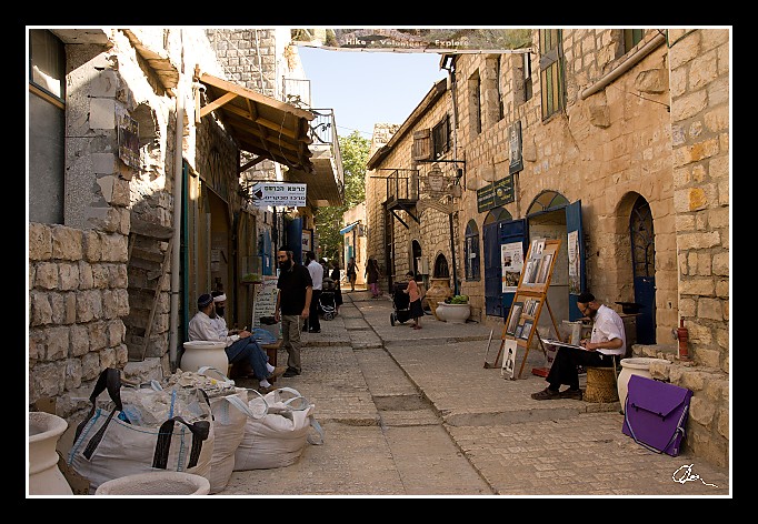
| A takhle to vypadá celkově a bez turistů naši skupinu jsem musel pochopitelně setřást :)). |
| 2 GPS 27. 06. 2010 16:40:55, Izrael - Safed, 1/250 sec, f 6.3, ISO 400 , 20 mm, Blesk No Flash |
Cesta
2010/06 cerven/27 Galilea, Golany a plavba/20100627-092.jpgContains Exchangeable Image File Format (EXIF) Information
Main Image Information
| Image Width | 682 pixels |
| Image Length | 472 pixels |
| Compression | Uncompressed |
| Photometric Interpretation | RGB (Red Green Blue) |
| Make (Manufacturer) | Canon |
| Model | Canon EOS 40D |
| X Resolution | 1207959552/16777216 (72) pixels per 'Resolution Unit' |
| Y Resolution | 1207959552/16777216 (72) pixels per 'Resolution Unit' |
| Planar Configuration | Chunky Format |
| Resolution Unit | Inches |
| Date and Time | 2010:07:08 10:31:58 (Format: YYYY:MM:DD HH:mm:SS) |
| YCbCr Positioning | Chrominance components Centred in relation to luminance components |
EXIF Image File Directory (IFD) contents
| Exposure Time | 1/250 (0.004) seconds |
| Aperture F Number | 63/10 (6.3) |
| Exposure Program | Aperture priority |
| ISO Speed Ratings | 400 |
| Exif Version | 0221 |
| Date and Time of Original | 2010:06:27 16:40:55 |
| Date and Time when Digitized | 2010:06:27 16:40:55 |
| APEX Shutter Speed Value (Tv) | 7965784/1000000 (7.965784) |
| APEX Aperture Value (Av) | 5310704/1000000 (5.310704) |
| APEX Exposure Bias Value (Exposure Compensation) | 0/1 (0) EV |
| Metering Mode | Pattern |
| Flash | Flash did not fire, compulsory flash suppression mode |
| FocalLength | 20/1 (20) mm |
| Sub Second Time of Original | 20 |
| Sub Second Time when Digitized | 20 |
| Focal Plane X Resolution | 3888000/876 (4438.3561643836) pixels per 'Focal Plane Resolution Unit' |
| Focal Plane Y Resolution | 2592000/583 (4445.9691252144) pixels per 'Focal Plane Resolution Unit' |
| Focal Plane Resolution Unit | Inches |
| Special Processing (Custom Rendered) | Normal process |
| Exposure Mode | Auto exposure |
| White Balance | Manual white balance |
| Scene Capture Type | Standard |
| Pixel X Dimension | 682 pixels |
| Pixel Y Dimension | 472 pixels |
| Colour Space | Uncalibrated |
| Components Configuration | Component 1: Y (Luminance) Component 2: Cb (Chroma minus Blue) Component 3: Cr (Chroma minus Red) Component 4: Does not exist |
| User Comment |
GPS Info Image File Directory (IFD) contents
| Longitude | 35/1 (35), 2948790/100000 (29.4879), 0/0 (Degrees Minutes Seconds East or West) |
| East or West Longitude | E |
| Latitude | 32/1 (32), 5816550/100000 (58.1655), 0/0 (Degrees Minutes Seconds North or South) |
| North or South Latitude | N |
| Altitude | 774960/1000 (774.96) Metres with respect to Altitude Reference |
| Altitude Reference | Sea Level |
Contains Extensible Metadata Platform (XMP) / Resource Description Framework (RDF) Information
Dublin Core Metadata Initiative RDF Segment
| Creator(s) (Authors): | Ordered List: Ing. Daniel Žingor |
| Rights Statement: | List of Alternates: © Daniel Žingor |
| Subject and Keywords: | Unordered List: Reportáž The Best Of Web |
| Description (Caption): | List of Alternates: A takhle to vypadá celkově a bez turistů naši skupinu jsem musel pochopitelně setřást :)). |
XMP - embedded TIFF Segment
| Make: | Canon |
| Model: | Canon EOS 40D |
| Image Width: | 3888 |
| Image Length: | 2592 |
| Samples Per Pixel: | 3 |
| Bits Per Sample: | Ordered List: 16 16 16 |
| Photometric Interpretation: | 2 |
XMP - embedded EXIF Segment
| Exif Version: | 0221 |
| Exposure Time: | 1/250 |
| Shutter Speed Value: | 7965784/1000000 |
| F Number: | 63/10 |
| Aperture Value: | 5310704/1000000 |
| Exposure Program: | 3 |
| Date & Time of Original: | 2010-06-27T16:40:55.20+02:00 |
| Date & Time Digitized: | 2010-06-27T16:40:55.20+02:00 |
| Exposure Bias Value: | 0/1 |
| Metering Mode: | 5 |
| Focal Length: | 20/1 |
| Custom Rendered: | 0 |
| Exposure Mode: | 0 |
| White Balance: | 1 |
| Scene Capture Type: | 0 |
| Focal Plane X Resolution: | 3888000/876 |
| Focal Plane Y Resolution: | 2592000/583 |
| Focal Plane Resolution Unit: | 2 |
| ISO Speed Ratings: | Ordered List: 400 |
| Flash: | Fired = False Return = 0 Mode = 2 Function = False Red Eye Mode = False |
| Pixel X Dimension: | 3888 |
| Pixel Y Dimension: | 2592 |
| GPS Longitude: | 35,29.487900E |
| GPS Latitude: | 32,58.165501N |
| GPS Altitude: | 774960/1000 |
| GPS Altitude Reference: | 0 |
XMP Basic Segment
| Resource Last Modify Date: | 2010-06-27T21:22:59+02:00 |
| Original Creation Date: | 2010-06-27T16:40:55.20+02:00 |
| Unknown field xap:Rating: | 2 |
| Unknown field xap:Label: | Green |
Unknown RDF Segment 'aux'
| Unknown field aux:Lens: | 17.00 - 50.00 mm |
| Unknown field aux:Firmware: | Firmware Version 1.0.3 |
Photoshop RDF Segment
| Unknown field photoshop:LegacyIPTCDigest: | EA20940AFBF52D322CB867DF2CB70E1C |
Unknown RDF Segment 'znr'
| Unknown field znr:RawDevelopSettings: | UEsDBBQAAAAIANqq2zzZ4h3h1AIAAHcJAAAMAAAAc2V0dGluZ3MueG1sbZbNbtswDMfvA/YOeYCm ddI2QYtCQNEBPQ7YuRfFZmKhsmRQcrr01XbYI+0VJtvUp5uT+edPpEVRdP79+fv0iR+PDZxB6p59 /zaZzxKBN5fnvpcCGrZ5uvlCJdZg3XPbsh+Pb41+HzpQ9vL284D88/3ytq021brarbf71SuXQgK/ Wr1qydVlxVe95OcDn5hqt92vq4ft9cuv7ZzMh6UsHK048toehbSAjKBCJVaKU2sNq2aGLP+2LW/0 R3B6k7y1Vha5sd4dbO+XHIW9BDeZ5LXQ9YDcDghst7+9n6FU9WF4l6o+Wq76oEJZtt5TrNFIgoxm sjrxmjEIt0Ir5qpLm40aUWfhzknVEJmgENEO4f3GR1I/Dl50T6QdNXbcsttZJ4t8DXTacFH7VcEO dZcaTc/rWIyo+Piue1yHUi+SRb7BdMYiqJNrmB1FSLWIIW/EYNjmehsx0iJkWwTTatn4Psu0yMmh 00pe/DslCjHwu69117Pq2tfXKwQodCv8nmcjeFwJomc0Ygtjr8CkTUyCL3fdMyp0HVK5RlZmPBa/ LApEoLbcwvSyhJDiTwl1j1DbmXC/q/CwKR/oFP2K0AfGTrfatwGZsYVqaBTvgIUu8kJ2t60/i7vs ktviiOh2L+hSz2IfJKjGiE9g+yx41PPoS37hKOIP2Ai3pXFi3RYpEleZ5YtVX/myXG4ggDLjiLq7 TxNFPc+y5BeOLD6c2TY78CDncRdc1H13agX1gGd/8tHORkQrjpalE2ISCDkhv6D7MPnyeDtxnxBA sfuHCMxKgrhqunm4icQkBEAPvbvD2owjOkCpmJJuOqZMHJaTOe0gA2Zlwcy7rEqw2LyT4yRIoy7m w6TGCqfsou6TqrQw4Eo51PMXJVlQuLIMYcBkGcqxQxtSZ0BTRk/kjHbNjrxHPX4G8gWZJ13TNpj/ MSjUgi3+KJRySo9NYmouIYOj6tib/E/Wf1BLAQIAABQAAAAIANqq2zzZ4h3h1AIAAHcJAAAMAAAA AAAAAAEAIAAAAAAAAABzZXR0aW5ncy54bWxQSwUGAAAAAAEAAQA6AAAA/gIAAAAA |
Unknown RDF Segment 'Iptc4xmpCore'
| Unknown field Iptc4xmpCore:Location: | Izrael - Safed |


