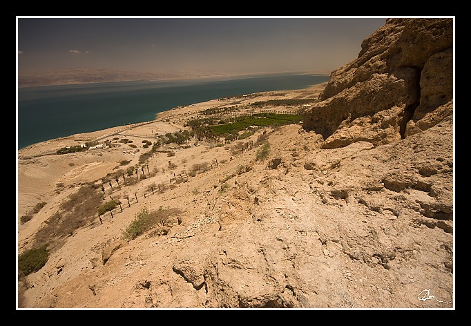
| Jsem nahoře - předemnou jsou plantáže, Mrtvé moře a Jordánsko. |
|
| 3 GPS 24. 06. 2010 13:14:44, Izrael - En Gedi, 1/125 sec, f 9, ISO 100 , 10 mm, Blesk No Flash |
Cesta
2010/06 cerven/24 Qumran, En Gedi a Wadi Quelt/20100624-076.jpgContains Exchangeable Image File Format (EXIF) Information
Main Image Information
| Image Width | 682 pixels |
| Image Length | 472 pixels |
| Compression | Uncompressed |
| Photometric Interpretation | RGB (Red Green Blue) |
| Make (Manufacturer) | Canon |
| Model | Canon EOS 40D |
| X Resolution | 1207959552/16777216 (72) pixels per 'Resolution Unit' |
| Y Resolution | 1207959552/16777216 (72) pixels per 'Resolution Unit' |
| Planar Configuration | Chunky Format |
| Resolution Unit | Inches |
| Date and Time | 2010:07:03 17:41:57 (Format: YYYY:MM:DD HH:mm:SS) |
| YCbCr Positioning | Chrominance components Centred in relation to luminance components |
EXIF Image File Directory (IFD) contents
| Exposure Time | 1/125 (0.008) seconds |
| Aperture F Number | 9/1 (9) |
| Exposure Program | Aperture priority |
| ISO Speed Ratings | 100 |
| Exif Version | 0221 |
| Date and Time of Original | 2010:06:24 13:14:44 |
| Date and Time when Digitized | 2010:06:24 13:14:44 |
| APEX Shutter Speed Value (Tv) | 6965784/1000000 (6.965784) |
| APEX Aperture Value (Av) | 633985/100000 (6.33985) |
| APEX Exposure Bias Value (Exposure Compensation) | 0/1 (0) EV |
| Metering Mode | Pattern |
| Flash | Flash did not fire, compulsory flash suppression mode |
| FocalLength | 10/1 (10) mm |
| Sub Second Time of Original | 01 |
| Sub Second Time when Digitized | 01 |
| Focal Plane X Resolution | 3888000/876 (4438.3561643836) pixels per 'Focal Plane Resolution Unit' |
| Focal Plane Y Resolution | 2592000/583 (4445.9691252144) pixels per 'Focal Plane Resolution Unit' |
| Focal Plane Resolution Unit | Inches |
| Special Processing (Custom Rendered) | Normal process |
| Exposure Mode | Auto exposure |
| White Balance | Manual white balance |
| Scene Capture Type | Standard |
| Pixel X Dimension | 682 pixels |
| Pixel Y Dimension | 472 pixels |
| Colour Space | Uncalibrated |
| Components Configuration | Component 1: Y (Luminance) Component 2: Cb (Chroma minus Blue) Component 3: Cr (Chroma minus Red) Component 4: Does not exist |
| User Comment |
GPS Info Image File Directory (IFD) contents
| Longitude | 35/1 (35), 2397277/100000 (23.97277), 0/0 (Degrees Minutes Seconds East or West) |
| East or West Longitude | E |
| Latitude | 31/1 (31), 2752080/100000 (27.5208), 0/0 (Degrees Minutes Seconds North or South) |
| North or South Latitude | N |
| Altitude | 411310/1000 (411.31) Metres with respect to Altitude Reference |
| Altitude Reference | Sea level reference (negative value) |
Contains Extensible Metadata Platform (XMP) / Resource Description Framework (RDF) Information
Dublin Core Metadata Initiative RDF Segment
| Creator(s) (Authors): | Ordered List: Ing. Daniel Žingor |
| Rights Statement: | List of Alternates: © Daniel Žingor |
| Description (Caption): | List of Alternates: Jsem nahoře - předemnou jsou plantáže, Mrtvé moře a Jordánsko. |
| Subject and Keywords: | Unordered List: Reportáž Krajina Web |
XMP - embedded TIFF Segment
| Make: | Canon |
| Model: | Canon EOS 40D |
| Image Width: | 3888 |
| Image Length: | 2592 |
| Samples Per Pixel: | 3 |
| Bits Per Sample: | Ordered List: 16 16 16 |
| Photometric Interpretation: | 2 |
XMP - embedded EXIF Segment
| Exif Version: | 0221 |
| Exposure Time: | 1/125 |
| Shutter Speed Value: | 6965784/1000000 |
| F Number: | 9/1 |
| Aperture Value: | 633985/100000 |
| Exposure Program: | 3 |
| Date & Time of Original: | 2010-06-24T13:14:44.01+02:00 |
| Date & Time Digitized: | 2010-06-24T13:14:44.01+02:00 |
| Exposure Bias Value: | 0/1 |
| Metering Mode: | 5 |
| Focal Length: | 10/1 |
| Custom Rendered: | 0 |
| Exposure Mode: | 0 |
| White Balance: | 1 |
| Scene Capture Type: | 0 |
| Focal Plane X Resolution: | 3888000/876 |
| Focal Plane Y Resolution: | 2592000/583 |
| Focal Plane Resolution Unit: | 2 |
| ISO Speed Ratings: | Ordered List: 100 |
| Flash: | Fired = False Return = 0 Mode = 2 Function = False Red Eye Mode = False |
| Pixel X Dimension: | 3888 |
| Pixel Y Dimension: | 2592 |
| GPS Longitude: | 35,23.972771E |
| GPS Latitude: | 31,27.520800N |
| GPS Altitude: | 411310/1000 |
| GPS Altitude Reference: | 1 |
XMP Basic Segment
| Resource Last Modify Date: | 2010-06-24T22:10:35+02:00 |
| Original Creation Date: | 2010-06-24T13:14:44.01+02:00 |
| Unknown field xap:Rating: | 3 |
| Unknown field xap:Label: | Green |
Unknown RDF Segment 'aux'
| Unknown field aux:Lens: | 10.00 - 20.00 mm |
| Unknown field aux:Firmware: | Firmware Version 1.0.3 |
Photoshop RDF Segment
| Unknown field photoshop:LegacyIPTCDigest: | EA20940AFBF52D322CB867DF2CB70E1C |
Unknown RDF Segment 'znr'
| Unknown field znr:RawDevelopSettings: | UEsDBBQAAAAIAE6x2DwCVNTR0wIAAKIJAAAMAAAAc2V0dGluZ3MueG1sbZbNbtswDMfvA/YmTes4 X1hRCCi2+4Cde1FlJhZqS4Ykp0tfbYc90l5hsk3qy81J/PNHyqJoOv/+/H36MO+PDVyh0wP7+mU2 nzsDvLk9D0MnoWHbp4dPVGStEQN3Lfvx+NLot7EH5W4vP18N/3i7vdTVttpUx029n5fVsd5vqtPx /vuveslJ0ZiMGyfPXLiz7BwYhlChItvJS+ssqxYGLXqoljf6PTjJRK/QyhluHbmDTf6OG+luwY0m eh30AxjuRgPseNodFihVKQ3vU5Wy5SollcqxzQlzTUaSZDKT6MRrpyTcSa2Yry4eNmpIXaW/DiUg MkFBoh3D801LVN9fSfQr1M7a9Nyx3aKjhb4Gem25FBQV7FD3Ths7cBGLERXKLzvwjYgthxb6Rttb Z0BdfMMcMUOqRczwRo6Wbe/riKEWIdcasK3uGuqzTItcN/ZadTd6pkRBBn4PQvcDq+6pvqQgoIyP oDMvRvD4EkTPZMQWNoMCmzYxClRuMTAstAhb+UZWdroWCosCEkY77mB+WERQoVsyejAg3EL4311Y bMsF3iJFhD6wbn6rqQ3QjC0koFG8Bxa6iITs3XZ0F/vsJXfFFeHbvaJLPcv92oFqrPwAdsqSRz3P vuZXjiL/aBrpjzRNrF2xReIqd/kk6jNftpcfCKDsNKL2h3SjqOe7rPmVI8sPV1ZnFx7kPO+Kizp1 p1YgRnP1Nz+bYtDzcLujZkWBcDTrXX1XHw4r5iHPmY2ZVp4dS6fMLCByMfxm/DeMSkx24r4YAMUO 3yKwKAnib8TP1G0kZiEAehz8HNB2GvMBSsWU9BM2ZeLAnc35BBmwKCtmOWVVgsXhvRynSZp1NWNm NVY4ZVd1n1WlpQVfylEsX6UkoHBlO4Qhle1Qji48kLqCsWX2RM5o/8IYPhg9fUrygMyTxrSNyf9c FGrBFn82SjmlpyaxgneQwVGlno7/x/4DUEsBAgAAFAAAAAgATrHYPAJU1NHTAgAAogkAAAwAAAAA AAAAAQAgAAAAAAAAAHNldHRpbmdzLnhtbFBLBQYAAAAAAQABADoAAAD9AgAAAAA= |
Unknown RDF Segment 'Iptc4xmpCore'
| Unknown field Iptc4xmpCore:Location: | Izrael - En Gedi |
