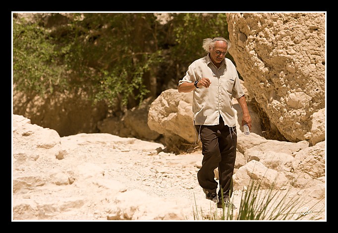
| Místní domorodec - šlapající rovněž k Davidovým vodopádům. |
|
| 2 GPS 24. 06. 2010 13:48:36, Izrael - En Gedi, 1/8000 sec, f 3.2, ISO 400 , 150 mm, Blesk No Flash |
Cesta
2010/06 cerven/24 Qumran, En Gedi a Wadi Quelt/20100624-088.jpgContains Exchangeable Image File Format (EXIF) Information
Main Image Information
| Image Width | 682 pixels |
| Image Length | 472 pixels |
| Compression | Uncompressed |
| Photometric Interpretation | RGB (Red Green Blue) |
| Make (Manufacturer) | Canon |
| Model | Canon EOS 40D |
| X Resolution | 1207959552/16777216 (72) pixels per 'Resolution Unit' |
| Y Resolution | 1207959552/16777216 (72) pixels per 'Resolution Unit' |
| Planar Configuration | Chunky Format |
| Resolution Unit | Inches |
| Date and Time | 2010:07:03 17:42:01 (Format: YYYY:MM:DD HH:mm:SS) |
| YCbCr Positioning | Chrominance components Centred in relation to luminance components |
EXIF Image File Directory (IFD) contents
| Exposure Time | 1/8000 (0.000125) seconds |
| Aperture F Number | 32/10 (3.2) |
| Exposure Program | Aperture priority |
| ISO Speed Ratings | 400 |
| Exif Version | 0221 |
| Date and Time of Original | 2010:06:24 13:48:36 |
| Date and Time when Digitized | 2010:06:24 13:48:36 |
| APEX Shutter Speed Value (Tv) | 12965784/1000000 (12.965784) |
| APEX Aperture Value (Av) | 3356144/1000000 (3.356144) |
| APEX Exposure Bias Value (Exposure Compensation) | -1/3 (-0.33333333333333) EV |
| Metering Mode | Spot |
| Flash | Flash did not fire, compulsory flash suppression mode |
| FocalLength | 150/1 (150) mm |
| Sub Second Time of Original | 15 |
| Sub Second Time when Digitized | 15 |
| Focal Plane X Resolution | 3888000/876 (4438.3561643836) pixels per 'Focal Plane Resolution Unit' |
| Focal Plane Y Resolution | 2592000/583 (4445.9691252144) pixels per 'Focal Plane Resolution Unit' |
| Focal Plane Resolution Unit | Inches |
| Special Processing (Custom Rendered) | Normal process |
| Exposure Mode | Auto exposure |
| White Balance | Manual white balance |
| Scene Capture Type | Standard |
| Pixel X Dimension | 682 pixels |
| Pixel Y Dimension | 472 pixels |
| Colour Space | Uncalibrated |
| Components Configuration | Component 1: Y (Luminance) Component 2: Cb (Chroma minus Blue) Component 3: Cr (Chroma minus Red) Component 4: Does not exist |
| User Comment |
GPS Info Image File Directory (IFD) contents
| Longitude | 35/1 (35), 2383620/100000 (23.8362), 0/0 (Degrees Minutes Seconds East or West) |
| East or West Longitude | E |
| Latitude | 31/1 (31), 2745030/100000 (27.4503), 0/0 (Degrees Minutes Seconds North or South) |
| North or South Latitude | N |
| Altitude | 388720/1000 (388.72) Metres with respect to Altitude Reference |
| Altitude Reference | Sea level reference (negative value) |
Contains Extensible Metadata Platform (XMP) / Resource Description Framework (RDF) Information
Dublin Core Metadata Initiative RDF Segment
| Creator(s) (Authors): | Ordered List: Ing. Daniel Žingor |
| Rights Statement: | List of Alternates: © Daniel Žingor |
| Description (Caption): | List of Alternates: Místní domorodec - šlapající rovněž k Davidovým vodopádům. |
| Subject and Keywords: | Unordered List: Reportáž Portrét The Best Of Web |
XMP - embedded TIFF Segment
| Make: | Canon |
| Model: | Canon EOS 40D |
| Image Width: | 3888 |
| Image Length: | 2592 |
| Samples Per Pixel: | 3 |
| Bits Per Sample: | Ordered List: 16 16 16 |
| Photometric Interpretation: | 2 |
XMP - embedded EXIF Segment
| Exif Version: | 0221 |
| Exposure Time: | 1/8000 |
| Shutter Speed Value: | 12965784/1000000 |
| F Number: | 32/10 |
| Aperture Value: | 3356144/1000000 |
| Exposure Program: | 3 |
| Date & Time of Original: | 2010-06-24T13:48:36.15+02:00 |
| Date & Time Digitized: | 2010-06-24T13:48:36.15+02:00 |
| Exposure Bias Value: | -1/3 |
| Metering Mode: | 3 |
| Focal Length: | 150/1 |
| Custom Rendered: | 0 |
| Exposure Mode: | 0 |
| White Balance: | 1 |
| Scene Capture Type: | 0 |
| Focal Plane X Resolution: | 3888000/876 |
| Focal Plane Y Resolution: | 2592000/583 |
| Focal Plane Resolution Unit: | 2 |
| ISO Speed Ratings: | Ordered List: 400 |
| Flash: | Fired = False Return = 0 Mode = 2 Function = False Red Eye Mode = False |
| Pixel X Dimension: | 3888 |
| Pixel Y Dimension: | 2592 |
| GPS Longitude: | 35,23.836201E |
| GPS Latitude: | 31,27.450300N |
| GPS Altitude: | 388720/1000 |
| GPS Altitude Reference: | 1 |
XMP Basic Segment
| Resource Last Modify Date: | 2010-06-24T22:13:29+02:00 |
| Original Creation Date: | 2010-06-24T13:48:36.15+02:00 |
| Unknown field xap:Rating: | 2 |
| Unknown field xap:Label: | Green |
Unknown RDF Segment 'aux'
| Unknown field aux:Lens: | 70.00 - 200.00 mm |
| Unknown field aux:Firmware: | Firmware Version 1.0.3 |
Photoshop RDF Segment
| Unknown field photoshop:LegacyIPTCDigest: | EA20940AFBF52D322CB867DF2CB70E1C |
Unknown RDF Segment 'znr'
| Unknown field znr:RawDevelopSettings: | UEsDBBQAAAAIAKux2DzvILAQvQIAAF4JAAAMAAAAc2V0dGluZ3MueG1sbZbNbtswDMfvA/YmS+uk afqBQkCx3Qfs3IsqM7FQWTIoOV36ajvskfYKk23q081J/PFPyqJoOv/+/H36wPfHFs6gzMC+fpnN Z4XA28vzMCgJLds+XX9CSWtRDNx17MfjS2vexh60u7z8fEX+8XZ52TXbZtMcNrv9vGwOu/2mub+/ +v5rt+QM0ZSMo5NHLtxRKgfISFRR0ip56pxlzaIhKzxUx1vzHp3BJK8w2iG3LrijHfyKo3SX6CaT vA76AZC7EYEd7m5uF1FOQxre5zRkK2lIKrVjmzvKNRlZksnMojOvnZJwJ41mvrp02MRIdZb+OrSA pImEFN0Yn29aEn1/DdCviB0N9tyxm4WTRb4WemO5FCEq2rHuyqAduEjFSCTklwp8I1LLkUW+0fbW IeiTb5gDZchZkiFv5WjZ9mqXZMSSyHUItjOqDX1WsKRTY2+0uoRnyghp4PcgTD+w5irUNxASaPQR 4cyLET2+BMkzGamFcdBg8yYmEMotBkaFFnEr38jaTtcSwhIgBRrHHcwPSxIi4ZbQDAjCLQr/+xYX 23pBtxgiYh9YN7/VoQ3ITC0koNW8Bxa7KIDi3XbhLvbFS+6qK6K3e6WueZH7VYFurfwAdlckT7zM vtavHFX+EVvpjzRNrJtqi8xV7/JJ1Ge+Yi8/EEDbaUTtb/ONEi93WetXjiI/nNmuuPCIy7wrXeKh O40GMeI53HyyixHRyaNj+YSYAUlOyC/ovz+hPMHO3CcE0Oz2IQkWkkl8Nf083CbFDKLAjIN/h42d RnQU5TBX+umYa9KwnM35BIVgISvNcsqmFlaH9zhNgjzraj7MNFU4167qPlNtpAVfylEsX5QsoHIV O8QBU+xQjx06kD4D2jp7hgu1b3bkA5rpM1AGFJ48pmux/GNQ0Upb/VGoca6emsQKrqAQJ+q11+V/ qf9QSwECAAAUAAAACACrsdg87yCwEL0CAABeCQAADAAAAAAAAAABACAAAAAAAAAAc2V0dGluZ3Mu eG1sUEsFBgAAAAABAAEAOgAAAOcCAAAAAA== |
Unknown RDF Segment 'Iptc4xmpCore'
| Unknown field Iptc4xmpCore:Location: | Izrael - En Gedi |
