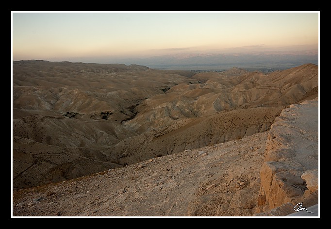
| Tady je pohled na druhou stranu směrem k Jerichu - to ostatně i v pozadí vpravo vidíme. |
|
| 3 GPS 24. 06. 2010 19:32:36, Izrael - Wádí Quelt, 1/50 sec, f 13, ISO 400 , 20 mm, Blesk No Flash |
Cesta
2010/06 cerven/24 Qumran, En Gedi a Wadi Quelt/20100624-105.jpgContains Exchangeable Image File Format (EXIF) Information
Main Image Information
| Image Width | 682 pixels |
| Image Length | 472 pixels |
| Compression | Uncompressed |
| Photometric Interpretation | RGB (Red Green Blue) |
| Make (Manufacturer) | Canon |
| Model | Canon EOS 40D |
| X Resolution | 1207959552/16777216 (72) pixels per 'Resolution Unit' |
| Y Resolution | 1207959552/16777216 (72) pixels per 'Resolution Unit' |
| Planar Configuration | Chunky Format |
| Resolution Unit | Inches |
| Date and Time | 2010:07:03 17:42:07 (Format: YYYY:MM:DD HH:mm:SS) |
| YCbCr Positioning | Chrominance components Centred in relation to luminance components |
EXIF Image File Directory (IFD) contents
| Exposure Time | 1/50 (0.02) seconds |
| Aperture F Number | 13/1 (13) |
| Exposure Program | Aperture priority |
| ISO Speed Ratings | 400 |
| Exif Version | 0221 |
| Date and Time of Original | 2010:06:24 19:32:36 |
| Date and Time when Digitized | 2010:06:24 19:32:36 |
| APEX Shutter Speed Value (Tv) | 5643856/1000000 (5.643856) |
| APEX Aperture Value (Av) | 7400879/1000000 (7.400879) |
| APEX Exposure Bias Value (Exposure Compensation) | -2/3 (-0.66666666666667) EV |
| Metering Mode | Pattern |
| Flash | Flash did not fire, compulsory flash suppression mode |
| FocalLength | 20/1 (20) mm |
| Sub Second Time of Original | 01 |
| Sub Second Time when Digitized | 01 |
| Focal Plane X Resolution | 3888000/876 (4438.3561643836) pixels per 'Focal Plane Resolution Unit' |
| Focal Plane Y Resolution | 2592000/583 (4445.9691252144) pixels per 'Focal Plane Resolution Unit' |
| Focal Plane Resolution Unit | Inches |
| Special Processing (Custom Rendered) | Normal process |
| Exposure Mode | Auto exposure |
| White Balance | Manual white balance |
| Scene Capture Type | Standard |
| Pixel X Dimension | 682 pixels |
| Pixel Y Dimension | 472 pixels |
| Colour Space | Uncalibrated |
| Components Configuration | Component 1: Y (Luminance) Component 2: Cb (Chroma minus Blue) Component 3: Cr (Chroma minus Red) Component 4: Does not exist |
| User Comment |
GPS Info Image File Directory (IFD) contents
| Longitude | 35/1 (35), 1222518/100000 (12.22518), 0/0 (Degrees Minutes Seconds East or West) |
| East or West Longitude | E |
| Latitude | 31/1 (31), 4318992/100000 (43.18992), 0/0 (Degrees Minutes Seconds North or South) |
| North or South Latitude | N |
| Altitude | 773040/1000 (773.04) Metres with respect to Altitude Reference |
| Altitude Reference | Sea Level |
Contains Extensible Metadata Platform (XMP) / Resource Description Framework (RDF) Information
Dublin Core Metadata Initiative RDF Segment
| Creator(s) (Authors): | Ordered List: Ing. Daniel Žingor |
| Rights Statement: | List of Alternates: © Daniel Žingor |
| Description (Caption): | List of Alternates: Tady je pohled na druhou stranu směrem k Jerichu - to ostatně i v pozadí vpravo vidíme. |
| Subject and Keywords: | Unordered List: Reportáž Krajina Web |
XMP - embedded TIFF Segment
| Make: | Canon |
| Model: | Canon EOS 40D |
| Image Width: | 3888 |
| Image Length: | 2592 |
| Samples Per Pixel: | 3 |
| Bits Per Sample: | Ordered List: 16 16 16 |
| Photometric Interpretation: | 2 |
XMP - embedded EXIF Segment
| Exif Version: | 0221 |
| Exposure Time: | 1/50 |
| Shutter Speed Value: | 5643856/1000000 |
| F Number: | 13/1 |
| Aperture Value: | 7400879/1000000 |
| Exposure Program: | 3 |
| Date & Time of Original: | 2010-06-24T19:32:36.01+02:00 |
| Date & Time Digitized: | 2010-06-24T19:32:36.01+02:00 |
| Exposure Bias Value: | -2/3 |
| Metering Mode: | 5 |
| Focal Length: | 20/1 |
| Custom Rendered: | 0 |
| Exposure Mode: | 0 |
| White Balance: | 1 |
| Scene Capture Type: | 0 |
| Focal Plane X Resolution: | 3888000/876 |
| Focal Plane Y Resolution: | 2592000/583 |
| Focal Plane Resolution Unit: | 2 |
| ISO Speed Ratings: | Ordered List: 400 |
| Flash: | Fired = False Return = 0 Mode = 2 Function = False Red Eye Mode = False |
| Pixel X Dimension: | 3888 |
| Pixel Y Dimension: | 2592 |
| GPS Longitude: | 35,12.225180E |
| GPS Latitude: | 31,43.189919N |
| GPS Altitude: | 773040/1000 |
| GPS Altitude Reference: | 0 |
XMP Basic Segment
| Resource Last Modify Date: | 2010-06-24T22:18:01+02:00 |
| Original Creation Date: | 2010-06-24T19:32:36.01+02:00 |
| Unknown field xap:Rating: | 3 |
| Unknown field xap:Label: | Green |
Unknown RDF Segment 'aux'
| Unknown field aux:Lens: | 10.00 - 20.00 mm |
| Unknown field aux:Firmware: | Firmware Version 1.0.3 |
Photoshop RDF Segment
| Unknown field photoshop:LegacyIPTCDigest: | EA20940AFBF52D322CB867DF2CB70E1C |
Unknown RDF Segment 'znr'
| Unknown field znr:RawDevelopSettings: | UEsDBBQAAAAIADuy2Dwu2EVC1QIAAKMJAAAMAAAAc2V0dGluZ3MueG1sbZbNbtswDMfvA/YmTes4 H8WKQkCx3Qfs3IsqM7FQWzIoOV36ajvskfYKk23q08lJ/PNHyqJoOv/+/H3+xI+nBi7Q6YF9/TKb Lx0Cb64vw9BJaNj2+eGGSqxBMXDbsh9Pr41+H3tQ9vr68w355/v1ta621aY6bur9vKyO9X6zrQ73 33/VS04fTck4Wnniwp5kZwEZQYVKbCfPrTWsWhiy/EO1vNEfwelN8gqtLHJjvTvY3t9xlPYa3GSS 10I/AHI7IrDj4+6wQKnq0/A+VX22XPVJpbJs80i5JiNJMplJdOI1UxJupVbMVZcOGzWiLtJdhxIQ maAQ0Y7h+aYlqR9vXnQr0k4ae27ZbtHJIl8DvTZcCh8V7FD3TqMZuIjFiIrPLztwjUgtRxb5RtMb i6DOrmGOlCHVIoa8kaNh2/s6YqRFyLYIptVd4/ss0yLXjb1W3dU/U6IQA78HofuBVfe+vl4hQKGL 8GdejOBxJYieyYgtjIMCkzYxCb7cYmBUaBG2co2szHQtPiwKRKC23ML8sISQ4m8J9YAg7EK4311Y bMsF3aKPCH1g7PxW+zYgM7aQgEbxHljoIi9k77b1d7HPXnJbXBG93Su61LPcbx2oxshPYI9Z8qjn 2df8ylHkH7GR7kjTxNoVWySucpcbUbd82V5uIIAy04jaH9KNop7vsuZXjiw/XFidXXiQ87wrLuq+ O7UCMeLF3fxsikFP02zneoy6lRTPk1nvDnf14bBiHvKk2Zxp5cmydMzMAiFn5Fd0HzFfY28n7jMC KHb4FoFFSRB3JW6obiMxCwHQ4+AGgTbTnA9QKqakG7EpEyfubM4nyIBFWTHLKasSLA7v5DhO0qyr ITOrscIpu6r7rCotDbhSjmL5LCUBhSvbIUypbIdydtGB1AXQlNkTOaPdG4N8QD19S/KAzJPGtA3m /y4KtWCLfxulnNJTkxjBO8jgqPqejn/I/gNQSwECAAAUAAAACAA7stg8LthFQtUCAACjCQAADAAA AAAAAAABACAAAAAAAAAAc2V0dGluZ3MueG1sUEsFBgAAAAABAAEAOgAAAP8CAAAAAA== |
Unknown RDF Segment 'Iptc4xmpCore'
| Unknown field Iptc4xmpCore:Location: | Izrael - Wádí Quelt |
