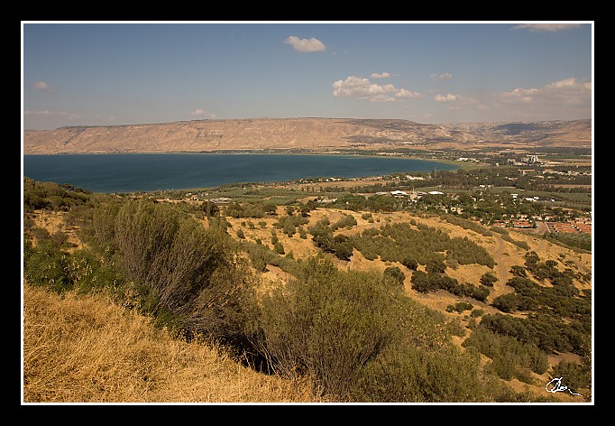
| A tady už Galilejské jezero - zásobuje 1/3 Izraele pitnou vodou a v zásadě platí rovnice, že kdo ovládá vodu (tedy Galilejské jezero) ovládá Izrael, dál taky platí, že kdo ovládá Golanské výšiny, ovládá celou Galileu (i s jeho jezerem :) ... |
|
| 2 GPS 26. 06. 2010 16:29:55, Izrael - Galilea, 1/400 sec, f 13, ISO 200 , 19 mm, Blesk No Flash |
Cesta
2010/06 cerven/26 Stary Jeruzalem, Jericho a Tiberias/20100626-072.jpgContains Exchangeable Image File Format (EXIF) Information
Main Image Information
| Compression | Uncompressed |
| Photometric Interpretation | RGB (Red Green Blue) |
| Make (Manufacturer) | Canon |
| Model | Canon EOS 40D |
| X Resolution | 1207959552/16777216 (72) pixels per 'Resolution Unit' |
| Y Resolution | 1207959552/16777216 (72) pixels per 'Resolution Unit' |
| Planar Configuration | Chunky Format |
| Resolution Unit | Inches |
| Date and Time | 2010:07:06 17:19:29 (Format: YYYY:MM:DD HH:mm:SS) |
| YCbCr Positioning | Chrominance components Centred in relation to luminance components |
EXIF Image File Directory (IFD) contents
| Exposure Time | 1/400 (0.0025) seconds |
| Aperture F Number | 13/1 (13) |
| Exposure Program | Aperture priority |
| ISO Speed Ratings | 200 |
| Exif Version | 0221 |
| Date and Time of Original | 2010:06:26 16:29:55 |
| Date and Time when Digitized | 2010:06:26 16:29:55 |
| APEX Shutter Speed Value (Tv) | 8643856/1000000 (8.643856) |
| APEX Aperture Value (Av) | 7400879/1000000 (7.400879) |
| APEX Exposure Bias Value (Exposure Compensation) | -1/3 (-0.33333333333333) EV |
| Metering Mode | Spot |
| Flash | Flash did not fire, compulsory flash suppression mode |
| FocalLength | 19/1 (19) mm |
| Sub Second Time of Original | 00 |
| Sub Second Time when Digitized | 00 |
| Focal Plane X Resolution | 3888000/876 (4438.3561643836) pixels per 'Focal Plane Resolution Unit' |
| Focal Plane Y Resolution | 2592000/583 (4445.9691252144) pixels per 'Focal Plane Resolution Unit' |
| Focal Plane Resolution Unit | Inches |
| Special Processing (Custom Rendered) | Normal process |
| Exposure Mode | Auto exposure |
| White Balance | Manual white balance |
| Scene Capture Type | Standard |
| Pixel X Dimension | 682 pixels |
| Pixel Y Dimension | 472 pixels |
| Colour Space | Uncalibrated |
| Components Configuration | Component 1: Y (Luminance) Component 2: Cb (Chroma minus Blue) Component 3: Cr (Chroma minus Red) Component 4: Does not exist |
| User Comment |
GPS Info Image File Directory (IFD) contents
| Longitude | 35/1 (35), 3299718/100000 (32.99718), 0/0 (Degrees Minutes Seconds East or West) |
| East or West Longitude | E |
| Latitude | 32/1 (32), 4302007/100000 (43.02007), 0/0 (Degrees Minutes Seconds North or South) |
| North or South Latitude | N |
| Altitude | 4940/1000 (4.94) Metres with respect to Altitude Reference |
| Altitude Reference | Sea Level |
Contains Extensible Metadata Platform (XMP) / Resource Description Framework (RDF) Information
Dublin Core Metadata Initiative RDF Segment
| Creator(s) (Authors): | Ordered List: Ing. Daniel Žingor |
| Rights Statement: | List of Alternates: © Daniel Žingor |
| Description (Caption): | List of Alternates: A tady už Galilejské jezero - zásobuje 1/3 Izraele pitnou vodou a v zásadě platí rovnice, že kdo ovládá vodu (tedy Galilejské jezero) ovládá Izrael, dál taky platí, že kdo ovládá Golanské výšiny, ovládá celou Galileu (i s jeho jezerem :) ... |
| Subject and Keywords: | Unordered List: Reportáž The Best Of Web |
XMP - embedded TIFF Segment
| Make: | Canon |
| Model: | Canon EOS 40D |
| Image Width: | 3888 |
| Image Length: | 2592 |
| Samples Per Pixel: | 3 |
| Bits Per Sample: | Ordered List: 16 16 16 |
| Photometric Interpretation: | 2 |
XMP - embedded EXIF Segment
| Exif Version: | 0221 |
| Exposure Time: | 1/400 |
| Shutter Speed Value: | 8643856/1000000 |
| F Number: | 13/1 |
| Aperture Value: | 7400879/1000000 |
| Exposure Program: | 3 |
| Date & Time of Original: | 2010-06-26T16:29:55.00+02:00 |
| Date & Time Digitized: | 2010-06-26T16:29:55.00+02:00 |
| Exposure Bias Value: | -1/3 |
| Metering Mode: | 3 |
| Focal Length: | 19/1 |
| Custom Rendered: | 0 |
| Exposure Mode: | 0 |
| White Balance: | 1 |
| Scene Capture Type: | 0 |
| Focal Plane X Resolution: | 3888000/876 |
| Focal Plane Y Resolution: | 2592000/583 |
| Focal Plane Resolution Unit: | 2 |
| ISO Speed Ratings: | Ordered List: 200 |
| Flash: | Fired = False Return = 0 Mode = 2 Function = False Red Eye Mode = False |
| Pixel X Dimension: | 3888 |
| Pixel Y Dimension: | 2592 |
| GPS Longitude: | 35,32.997181E |
| GPS Latitude: | 32,43.020069N |
| GPS Altitude: | 4940/1000 |
| GPS Altitude Reference: | 0 |
XMP Basic Segment
| Resource Last Modify Date: | 2010-06-26T22:07:14+02:00 |
| Original Creation Date: | 2010-06-26T16:29:55.00+02:00 |
| Unknown field xap:Rating: | 2 |
| Unknown field xap:Label: | Green |
Unknown RDF Segment 'aux'
| Unknown field aux:Lens: | 17.00 - 50.00 mm |
| Unknown field aux:Firmware: | Firmware Version 1.0.3 |
Photoshop RDF Segment
| Unknown field photoshop:LegacyIPTCDigest: | EA20940AFBF52D322CB867DF2CB70E1C |
Unknown RDF Segment 'znr'
| Unknown field znr:RawDevelopSettings: | UEsDBBQAAAAIAOWw2jxs3mNp0wIAAKIJAAAMAAAAc2V0dGluZ3MueG1sbZbNbtswDMfvA/YmTes4 TYIVhYBiuw/YuRdVZmKhtmRQcrr01XbYI+0VJtvUp5OT+OePlEXRdP79+fv8iR9PDVyg0wP7+mU2 XzoE3lxfhqGT0LDt88MNlViDYuC2ZT+eXhv9Pvag7PX15xvyz/fra11tq0112NSHeVkd6sOmOtb3 33/VS04fTck4Wnniwp5kZwEZQYVKbCfPrTWsWhiy/EO1vNEfwelN8gqtLHJjvTvY3t9xlPYa3GSS 10I/AHI7IrDDcbdfoFT1aXifqj5brvqkUlm2OVKuyUiSTGYSnXjNlIRbqRVz1aXDRo2oi3TXoQRE JihEtGN4vmlJ6sebF92KtJPGnlu2W3SyyNdArw2XwkcFO9S902gGLmIxouLzyw5cI1LLkUW+0fTG Iqiza5gDZUi1iCFv5GjY9r6OGGkRsi2CaXXX+D7LtMh1Y69Vd/XPlCjEwO9B6H5g1b2vr1cIUOgi /JkXI3hcCaJnMmIL46DApE1Mgi+3GBgVWoStXCMrM12LD4sCEagttzA/LCGk+FtCPSAIuxDudxcW 23JBt+gjQh8YO7/Vvg3IjC0koFG8Bxa6yAvZu239XTxmL7ktroje7hVd6lnutw5UY+QnsGOWPOp5 9jW/chT5R2ykO9I0sXbFFomr3OVG1C1ftpcbCKDMNKIe9+lGUc93WfMrR5YfLqzOLjzIed4VF3Xf nVqBGPHibn42xaDn4Xbnm5UEj5NZ7+q7er9fMQ95zmzMtPJkWTplZoGQM/Irum+YL7G3E/cZARTb f4vAoiSIuxE3U7eRmIUA6HFwc0CbacwHKBVT0k3YlIkDdzbnE2TAoqyY5ZRVCRaHd3KcJmnW1YyZ 1VjhlF3VfVaVlgZcKUexfJWSgMKV7RCGVLZDObroQOoCaMrsiZzR7oVBPqCePiV5QOZJY9oG8z8X hVqwxZ+NUk7pqUmM4B1kcFR9T8f/Y/8BUEsBAgAAFAAAAAgA5bDaPGzeY2nTAgAAogkAAAwAAAAA AAAAAQAgAAAAAAAAAHNldHRpbmdzLnhtbFBLBQYAAAAAAQABADoAAAD9AgAAAAA= |
Unknown RDF Segment 'Iptc4xmpCore'
| Unknown field Iptc4xmpCore:Location: | Izrael - Galilea |
